
Activity Feed › Discussion Forums › Strictly Surveying › What’s the dashed line for?
What’s the dashed line for?
Posted by RADAR on March 25, 2020 at 4:43 pmA friend of mine asked me what I thought the dashed line represented, on the westerly side of lot 2; so I thought I’d ask the good people here, what they thought.
I looked at the assessor’s map and the county road maps, and they all showed the same thing; a 60′ Right-of-Way, nothing more.
TIA
Dougie
steven-metelsky replied 4 years ago 12 Members · 24 Replies- 24 Replies


Appears to be a road widening or possibly a sight easement to prevent tree plantings and signs within that area. Semis turning have a fairly tight corner to make there. I note the county engineer has not signed off on the copy you have. Perhaps this is not the absolute final version.

Okay Dougie,
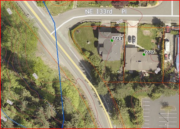
I’ve actually had my required 2 cups of coffee so I’ll give it a shot. It looks to me like they dedicated an additional 12′ to Juanita Drive as an afterthought. Look at the western edge of Tract ‘A’ across NE 133rd Place, it shows the additional 12′ of R/W dedicated to Juanita. It appears to be the same 12′ for the section that actually has dimensions given.

Yeah, I saw that too; but it isn’t labeled, other than: All Streets and Avenues…for public Highway purposes.
The plat was recorded on Valentine’s day, 1962; there was a bike lane designed in the 80’s that just showed a 60′ Right-of-Way, nothing more.
Might’ve been an after thought, that nobody payed attention to.
I hope everyone has a great day; I know I will!
@holy-cow I would second the sight distance easement, especially with the entrance being on a radius.

I agree – looks to be a ROW dedication. The dashed linetype within Lot 1 is the same as the ROW linetype outside the plat.
“…people will come to love their oppression, to adore the technologies that undo their capacities to think.” -Neil Postman
I’m going with future r/w dedication. Yet another reason that a land survey plat
and a development plan should handled individually.

I take that as nothing more than a line from which the 10′ regulatory building setback is measured from. Often comprehensive plans designate what a future road designation will be and identifies places where future widening might be needed. Since those plans are not binding on current regulations all that can be done is to ensure that improvements like houses can meet setbacks if and when a road widening takes place.
By the way, Leroy Middleton was the real deal. A respected and admired land surveyor, past president of LSAW, expert on tideland law and mentor to many. Although he passed many years ago, the firm that he started still carries his name. He once visited my office and we shot the bull for not enough hours. I leaned on him heavily for advice on a survey I was working on in Lilliwaup. If it has his signature on it you can trust that it was done properly.

I’m in the sight distance easement camp. But since it is unlabelled, it isn’t really anything, is it? Except a weird way of dimensioning the setback line. Unless there is some mention of that line in the deed or some other writing.
- Posted by: @daniel-ralph
Leroy Middleton was the real deal
I agree, I still refer to a publication I have, by Middleton on Water Boundaries in Washington. And followed several of there surveys; always spot on. Also sat in on several of his seminars; always educational and entertaining.
That’s why this one threw me; why wouldn’t this one have a label, or designation for this line?
Thank you for your insight! It was 1961, after all…
Doug
I hope everyone has a great day; I know I will! Doug if you are surveying here be forewarned that monuments set in 1962 were lost by the time I got there in 1984. We did Lots 3 and 4 and I can send field notes if you like but you’re not going to probably find our hard nails. Recovered one of Jerry Krell’s (Kegel Associates) pins at the NW corner of Lot 2 at that time but a lot of water has gone under the bridge since then.
Thanks Dan, I appreciate that. I’ll let my buddy know. I think they’re doing some work on Juanita Drive.
I hope everyone has a great day; I know I will!@dougie Sometimes issues like this make me I gravitate to the King County Roads Vault. Check out this https://info.kingcounty.gov/transportation/kcdot/roads/mapandrecordscenter/mapvault/Default.aspx?DocId=hLNal3HPlWM1
The short tangets in NE 133rd Place are unique. It appears to me that there were some last minute changes to the design.
Thanks Dan!
I did a quick search of that site; but didn’t see that one.
I hope everyone has a great day; I know I will!
The description makes reference to deed in auditor file 2575863. Does that deed address this area?
Eli

It’s most likely a road widening easement or taking. It is 12 feet wide and matches parcel A.
Filed Maps do not transfer title. A deed should be recorded into the appropriate governing body defining what that area is and how it is to be handled
Something I have seen on many recorded plats, especially several decades ago, are markings and handwritten notes that have been added at some time after recordation. This may be such an addition that was approved by the governing body. The trick would be to ever trace the motion/procedure that was passed/followed to the date it happened. We have this problem with cities who go through the process to vacate a street or alley yet fail to record that action in the county courthouse. They don’t realize that it ain’t over until it’s over…………….by providing public notice legally through recording the action there. By working through workers in one city office I was finally able to find that a certain alley was vacated in 1956 which was shortly prior to construction that would have needed the alley to be vacated first. The City then approved having that vacation officially recorded at the courthouse 62 years after the intended action.
They do when the map in question is a plat. Okay, they may not actually transfer title of the lots they create but the dedicated roadways and easements are conveyed to the public at time of recording.

an easement is an interest, it is not an estate in real property to which someone holds title.
Road dedications are often made and accepted on the Plat in West Coast States.
Log in to reply.