
Activity Feed › Discussion Forums › Strictly Surveying › switching from geoid 12b to geoid 18
switching from geoid 12b to geoid 18
Posted by casualsurveyor0192 on February 4, 2020 at 4:42 pmHello all. I recently worked with a surveyor who let me know that geoid 12b is being phased out for geoid 18. I am beggining to start this process but have a few general questions on repercussions. My workflow is essentailly, Do a static survey that is corrected with opus in with a 12b geoid, design a plan based on those coordinates in autocad (i dont think geoid is relevant in cad for this purpose but i could be wrong), put my design points in my controller and stake it in the field.
1.) what do i do with all my old data that is in geoid 12b? If I have a design elevation at 800.3 feet that was based on 12b, and I update my controller job settings to 18, wont that through off my elevations?
2.) Can I get a general overview of how NAVD and geoid 12b/18 interact with regards to elevation? I work in napa county and use their contours as a reference for projects where I do not need to be very precise (I topo a site myself for more exact jobs). their meta data is here . http://gis.napa.ca.gov/giscatalog/viewXML.asp?Name=maingis.GIS.cont_02_200&meta_style=fgdc Their altitude datum is the north american vertical datum of 1988, how much difference is that elevation relative to geoid 12b and 18?
3.) How do I stay up to date on these changes? I also heard that the US survey feet may be going away and a new coord system is coming out in 2022.
surv3251 replied 4 years, 2 months ago 10 Members · 25 Replies- 25 Replies

The differences in geoid heights between 12B and 18 vary by location, primarily because of the densification of available data used for GEOID18 resulting from the GPS on Bench Marks campaign(s). You can use this tool to compute a GEOID18 geoid height (N) for your project location, then compare that to what the geoid height was for 12B. The difference will be the amount your derived orthometric height will change depending on which geoid model you apply to the ellipsoid height(s).
https://www.ngs.noaa.gov/GEOID/GEOID18/computation.html
The area where you work has almost no NAVD88 bench marks, so it is unlikely any GPS on BM observations were done that would have changed the geoid heights in your area between 12B and 18.

@spmpls i got an output N of -31.095 M, or about 102 feet for a random spot on my drawing where i inserted a point. what does that number represent? elevation? Because both in the contours provided by napa county and our seperate survey data, the elevation we have is around 112 feet. both use navd88 i believe
H (NAVD88 elevation) = h (NAD83 ellipsoid height) – N (geoid height).
Your computation returned a GEOID18 geoid height for your entered location of -31.095 meters. You need to compare that value with what the 12B geoid height was for the same location. The difference, if any, will be the change in your derived NAVD88 orthometric height (elevation).
Here is the GEOID12B computation utility:
https://geodesy.noaa.gov/GEOID/GEOID12B/computation.html
@spmpls thank you very much. Lastly, is there a magazine or publication I can use to stay up to date on changes? I heard that opus may stop processsing data for 12b, is there any truth to that?
@spmpls thanks again. Looks like depending on my location, I tried one on the valley floor and one up on our highest project, the difference is about .08 ft (valley floor) and .12 feet (higher EL.) does this change in geoid height directly correlate to what the change in elevation would show had i been using geoid 18 in my surveying equipment?

———–Ellipsoid
^
|
N = a negative distance in most of California
|
———–Geoid
Actually, negative in all of California and the rest of the Conterminous U.S.
https://geodesy.noaa.gov/GEOID/GEOID18/maps/geoid18_conus_web.png
When grading the California PLS exam years ago, one of the questions was something like “at your project location, which is higher, the ellipsoid or geoid?” An examinee answered “ellipsoid”, which was correct, but then went on to state “Because the geoid is below the ellipsoid in all of the United States”, which is not correct. Last I checked Alaska is in the US. They got zero points for that answer because of that incorrect statement. I always told people taking the exam to just answer the question and move on. Don’t spend any time fortifying your answer and I used that situation as an example. All risk and no reward.

When I apply Geoid 18 in my area to NAD83 (2011) ellipsoid heights I tend to be closer to NAVD88 elevations than using Geoid 12b.
I normally correct the ellipsoid height to NAVD88 elevations with which ever flavor of Geoid I’m using.
In other words I fix my elevation and let the Geoid model move the ellipsoid height up or down.
Most people use the ellipsoid height and shift the elevation which causes you to have different elevations for each Geoid model, 90, 96, 99, 03, 09, 12, 18. So there would be at least seven different elevations for the same point through the last 28 years of GPS usage, or a change every four years or so. Of course each Epoch also changes the ellipsoid height and that adds to the number of elevation changes, 86, 93, 01, 07, 11. So mixing the seven Geoid model heights with the five ellipsoid heights can produce a large number of different elevations for the same point.
Basically, you need to stay on top of the changes, if you have an ongoing design like many engineering designs are, keep good records of how you derive elevations and let the next guy know where it all came from.

OPUS has been returning GEOID18 on results for a while now – as of September, I believe.
Keep tabs on the NGS homepage, they will always post up changes to products and services, often long in advance.
Or, if you don’t mind being notified by email, I highly recommend signing up for NGS alerts.
“…people will come to love their oppression, to adore the technologies that undo their capacities to think.” -Neil Postman- Posted by: @mightymoe
Basically, you need to stay on top of the changes, if you have an ongoing design like many engineering designs are, keep good records of how you derive elevations and let the next guy know where it all came from.
For sure. I can’t tell you how many times I have seen design surveys and plansets stating “Vertical datum is NAVD88” with absolutely no other information.
“…people will come to love their oppression, to adore the technologies that undo their capacities to think.” -Neil Postman 
The lesson is, “Pick a datum realization and geoid and stick with them for your whole project.” Later ones will be self-consistent over a larger area, but any recent one will probably do for most projects.
.
On the question of which model of ellipsoid-geoid separation, I always recommend the most recent be used. In any event, the choice of which model to use, like which horizontal and which vertical datums are used must be included in the documentation of the work.
Note that I use the term ellipsoid-geoid separation rather than geoid height. The value labeled ??geoid height? represents the linear distance from the surface of the reference ellipsoid to the geoid.
While the relationship is often expressed otherwise, I always use h – H – N = 0 (+ errors in h, H and N).Note that the NGS datasheets do not use this relationship to sum to zero. It extracts the three quantities separately from their database.
I obnoxiously include an annotated datasheet. I forgot to label H which is the distance from the geoid to the terrain.
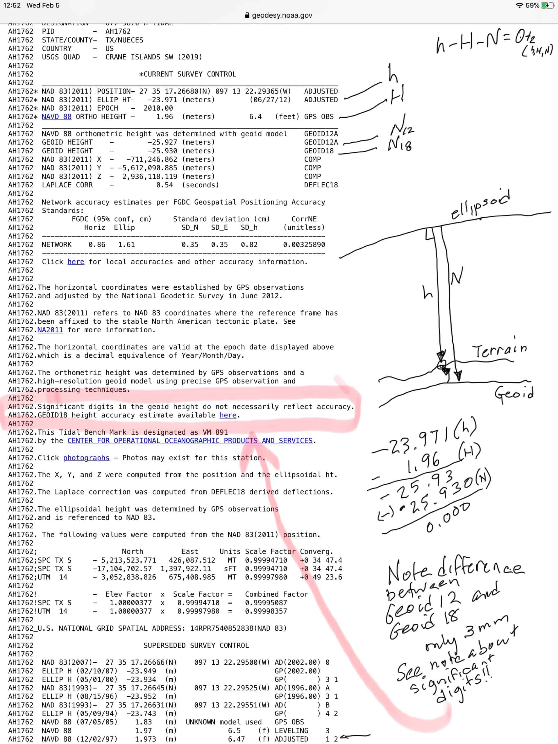
I often get asked which geoid model goes with which realization of NAD83 and why? I used to try to explain it, but now I simply provide the attached.
This was written pre 12B and 18, but the explanation is still applicable. They are called “models” for a reason.
@mightymoe do you know where i could find what ellipsoid my geoid is even referencing? right now in my trimble r10 tsc3 controller it is set to nad 1983, cal state plan II, and it ggives me the option to use a geoid model which i have checked, and it is set on geoid 12b. I don’t see anything about an elliposide.
 Posted by: @casualsurveyor0192
3.) How do I stay up to date on these changes? I also heard that the US survey feet may be going away and a new coord system is coming out in 2022.
Visit RPLStoday.com regularly. Works for me.
Also, be a member of your state’s surveyor organization. Read the newletters that are sent to membership. Attend your state’s annual surveyor conference. NSPS newsletters to members, via email. American Surveyor, XYHt, and POB magazines.
All NAD83 realizations use the GRS80 ellipsoid, but latitudes/longitudes/ellipsoid heights changed with each new realization.The NGS had to effectively compensate for the change in ellipsoid heights, i.e. ortho heights remained the same, so the geoid separation had to change.
@SPMPLS beat me to it and posted an article about which geoid to use with which NAD83 downthread. It’s a must-read for anyone who does work using geoid-derived heights, especially if you work on legacy projects:
“…people will come to love their oppression, to adore the technologies that undo their capacities to think.” -Neil PostmanThe practice advocated by this poster does not make sense. While in a perfect world the three heights: ellipsoid (h), orthometric (H) and ellipsoid to geoid separation (N) should sum to zero (i.e., h – H – N = 0 if all were perfectly determined), in the real world they generally do not.
Looking at an NGS data sheet, one sees that the source for each height type is annotated. The data sheet does NOT force any of the heights into agreement with the relationship h – H – N = 0. Take a sampling of data sheets and run the equation, most likely they will not sum to zero.
Using a CORS solution as an example, the NAD83(2011) ellipsoid height at the unknown represents the best determination for the day of observations with respect to well-determined positions of the CORS as well as well-determined positions for the satellites. I still like the “classic” static OPUS solution as the “peak-to-peak” differences provides a realistic estimate of the quality of the determination of the unknown’s position.
On NGS data sheets the vast majority of NAVD88 orthometric heights determined by differential leveling were determined decades ago. The NAVD88 network itself is acknowledged to have serious systematic errors especially the significant tilt from FL to WA.
As GNSS observations produce ellipsoid heights (in a three-dimensional datum like NAD83(2011) and differential leveling is based on the geoid (NAVD88 orthometric), there must be a way to link these two non-parallel height systems. They are linked by a model of the relationship of the ellipsoid to the geoid.
When using NAD83(2011) ellipsoid heights we use the current HYBRID geoid model (GEOID18) to best approximate an NAVD88 height. Note I capitalized hybrid above, I did so the differentiate it from the geophysical model. While based on the geophysical model, the hybrid geoid model must account for datum differences between NAD83 and ITRF values and using sources like the GPSonBM observations (where N is computed from observed NAD83 ellipsoid heights and published NAVD88 orthometric heights).
What the poster proposes is to force agreement between the three heights holding the unmonitored, unverified, NAVD88 heights and the GEOID18 hybrid geoid model (already including a corrector surface containing the relationship between NAD83 and NAVD88) to change current increasingly well-determined ellipsoid heights.
To constrain the GEOID18 value as correct also ignores the relatively large uncertainties in the model. Using AH1762 values as input in the on-line NGS tool ( https://www.ngs.noaa.gov/cgi-bin/GEOID_STUFF/geoid18_single.prl ) yields a 2-sigma error of 0.031 meters. Perhaps the poster might use the tool to examine the values for his points.

Log in to reply.