
Activity Feed › Discussion Forums › Strictly Surveying › SurvCE Hybrid, and others
SurvCE Hybrid, and others
Posted by Mark Mayer on November 21, 2018 at 7:45 pmI’m looking at the ad on the back cover of the November xyHt magazine. It is an ad for a data collector and instrument set up that allows you to operate the total station and GPS receiver at the same time. This is not the first time I’ve seen such a setup promoted. Leica had such a thing 20 years ago, for example, but it never caught on.
If any of you have tried this sort of setup to advantage I’d like to hear about your experiences. Just what does this feature – having the GPS piggybacked on the TS – really do for you?
azweig replied 5 years, 5 months ago 11 Members · 16 Replies- 16 Replies

I’ve often thought about that, but always concluded that if I got myself into that position I’d be standing in the perfect survey site (adjacent BBQ and all) and therefore it would be time to retire, immediately.

It depends on the size and weight of the GPS receiver.
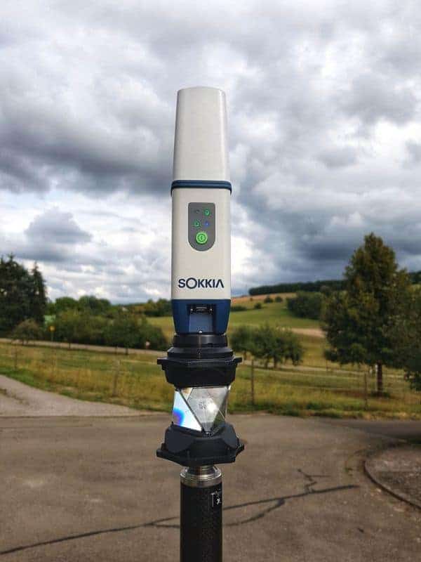
I use a Sokkia GCX3, carbon fiber pole & bipod, and I don’t mount the DC to the pole, so this is a very lightweight setup.
Some larger setups are just too awkward and can even break the prism. I have only used this with Topcon Magnet Tools. It takes only one button to swap between GPS and TS. You can set up the TS inside a building on an unknown position. Then locate two points through a window, or door that you can locate with both GPS/TS. You visit these points just one time. Performing a resection. This saves walking and setup time.

I??ve talked with Carlson about this. They are looking to rebrand a smaller receiver to mount on the 360 prism making for a lighter setup. I haven??t used it but can see advatages in resectioning in TS setups under the canopy of woods, interior to a building, or under a bridge very quickly. Thinking of other advantages where line of sight and clear sky could provide redundancy with a single shot.

It comes in handy when you take a shot, then have to tromp through the undergrowth/forest to the next layout point.
You don’t have to worry about keeping target lock. Get to the next point, hit search, and the GPS lets the TS know
where to look for your prism.
 Posted by: Richard Imrie
I’ve often thought about that, but always concluded that if I got myself into that position I’d be standing in the perfect survey site (adjacent BBQ and all) and therefore it would be time to retire, immediately.
Wow! Perfect survey site would be adjacent to: https://www.google.com/maps/place/Prasek’s+Hillje+Smokehouse/@29.7622991,-96.1896166,17z/data=!4m12!1m6!3m5!1s0x8641445da61674f3:0x5b6590d99b47a3b9!2sPrasek’s+Hillje+Smokehouse!8m2!3d29.7622991!4d-96.1874279!3m4!1s0x8641445da61674f3:0x5b6590d99b47a3b9!8m2!3d29.7622991!4d-96.1874279?hl=en
Quite possibly the best sliced brisket I’ve bought in some time.
Has absolutely nothing to do with the dual capability software currently being discussed.

If serving as an aid to refinding a lost target prism is the purpose, that can be achieved with a low dollar GPS chip and autonomous positioning.
 Posted by: Mark Mayer
I’m looking at the ad on the back cover of the November xyHt magazine. It is an ad for a data collector and instrument set up that allows you to operate the total station and GPS receiver at the same time. This is not the first time I’ve seen such a setup promoted. Leica had such a thing 20 years ago, for example, but it never caught on.
If any of you have tried this sort of setup to advantage I’d like to hear about your experiences. Just what does this feature – having the GPS piggybacked on the TS – really do for you?
I wouldn’t say it never caught on. I use it on Leica equipment from time to time.
The alternative is marking and measuring a few points with GPS then coming back and re-measuring with TS for a station setup.
So it can potentially a bit of walking and driving nails/pegs. I take the GPS off as soon as the station setup is done. Extra weight is not wanted. If there are points outside the view of the TS I’ll be picking them up after.

Lee Green – How do you “not mount the collector to the pole”
Do you use shoulder straps with a tablet” I would be interested in seeing this setup if that’s what you do, since I am looking to switch to a tablet style collector. I tried sending you a PM about these data collectors, but apparently can’t send messages as a noob?
Yes, I use Optics Binocular Harness Strap that holds the tablet on to my chest.

I use this set occasionally with our Trimble gear. They call it Integrated Surveying. I see the main purpose for it is that it allows you to resection without knowing the location of the points beforehand. It will shoot the point using GNSS, then shoot the point with the robot. Theoretically, you could just shoot the ground and not any type of control point. It also allows you to switch between GNSS and conventional to get shots that either need better accuracy than GNSS can provide, or in canopy situations.
I do not use this that often, as the pole is quite a bit heavier with our set up. I don’t think it would be too bad with a set up like @leegreen uses.
 Posted by: azweig
I use this set occasionally with our Trimble gear. They call it Integrated Surveying. I see the main purpose for it is that it allows you to resection without knowing the location of the points beforehand. It will shoot the point using GNSS, then shoot the point with the robot. Theoretically, you could just shoot the ground and not any type of control point. It also allows you to switch between GNSS and conventional to get shots that either need better accuracy than GNSS can provide, or in canopy situations.
I do not use this that often, as the pole is quite a bit heavier with our set up. I don’t think it would be too bad with a set up like @leegreen uses.
So the instrument position is resectioned using RTK points as control, is that it?
Yes. You measure two points at a single occupation with the rover pole. In a Hybrid resection app you measure point A with the EDM, then Measure it with RTK, move to point B and repeat. Now the TS has a position. Very quick, very simple. As mentioned you don’t need to leave a point for A and B, but I recommend you do.

I would have to agree that the Trimble setup is too heavy with or without the data collector.
- Posted by: Norman OklahomaPosted by: azweig
I use this set occasionally with our Trimble gear. They call it Integrated Surveying. I see the main purpose for it is that it allows you to resection without knowing the location of the points beforehand. It will shoot the point using GNSS, then shoot the point with the robot. Theoretically, you could just shoot the ground and not any type of control point. It also allows you to switch between GNSS and conventional to get shots that either need better accuracy than GNSS can provide, or in canopy situations.
I do not use this that often, as the pole is quite a bit heavier with our set up. I don’t think it would be too bad with a set up like @leegreen uses.
So the instrument position is resectioned using RTK points as control, is that it?
Yep
- Posted by: leegreen
Yes. You measure two points at a single occupation with the rover pole. In a Hybrid resection app you measure point A with the EDM, then Measure it with RTK, move to point B and repeat. Now the TS has a position. Very quick, very simple. As mentioned you don’t need to leave a point for A and B, but I recommend you do.
That’s kind of cool, but for the regularity of occasions where I would want to do that, it seems like kind of a gadget play (to use a football analogy) especially if you are going to monument the resect points. I think that having separate RTK and TS operations is probably cost effective. Perhaps with very specific applications….?
- Posted by: Norman OklahomaPosted by: leegreen
Yes. You measure two points at a single occupation with the rover pole. In a Hybrid resection app you measure point A with the EDM, then Measure it with RTK, move to point B and repeat. Now the TS has a position. Very quick, very simple. As mentioned you don’t need to leave a point for A and B, but I recommend you do.
That’s kind of cool, but for the regularity of occasions where I would want to do that, it seems like kind of a gadget play (to use a football analogy) especially if you are going to monument the resect points. I think that having separate RTK and TS operations is probably cost effective. Perhaps with very specific applications….?
The way I look at is, we have our robot and rover with us everyday and the ability to do this is built into Trimble Access. There is no add-on or any other fee to have this capability. If we can use it, we use it, if not, there is nothing lost.

Log in to reply.