
Activity Feed › Discussion Forums › Strictly Surveying › Section breakdown Sec 6
Section breakdown Sec 6
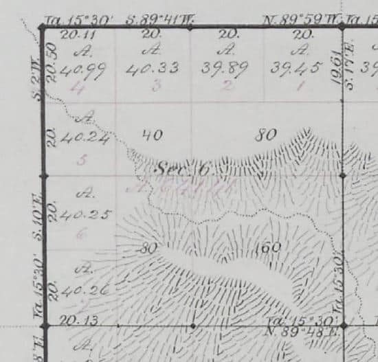
Posted by MightyMoe on August 10, 2018 at 3:23 pmSection 6 is always fun to breakdown, in this case the township and range lines were resurveyed prior to the interior of the township being run. That is why there are angle breaks along the north and west lines of Section 6. The question to be answered is do the angle breaks along the north and west lines of the section affect the dimensions used to position the CN1/16th and the CW1/16th corners. The angle breaks do not appear in the original notes, but do appear in the retracement survey and are shown on the plat.
 MightyMoe replied 5 years, 8 months ago 5 Members · 13 Replies
- 13 Replies


The question should be; Why wouldn’t the angle breaks along the north and west lines of the section affect the dimensions used to position the CN1/16th and the CW1/16th corners?
Lots of other questions; too. Are you the first to retrace this resurvey? Who has relied on what for occupation?
I hope everyone has a great day; I know I will!
No valid occupation (some fencing that is placed where it was possible to keep it up), yes probably the first to do a surveyed retracement although at least some of the originals were found over the years by ranchers. All stones are in place.

The two questions that need to be answered are, did the the resurvey change the area of the lots? and, was the land still federal at the time of the resurvey?
Usually, if the area didn’t change, or the land was already private at the time of the resurvey, the original survey would control the breakdown. If the area did change, and there was still a federal interest in the land, the resurvey would control.
What could change this is a plat note. Plats usually have no relevant note, or a note saying something like, “except as hereon indicated the lots and areas are as shown on the plat approved….” If there is a note that says something else, it may lead you to a different conclusion.
The resurvey happened before any sections were run. There were no homesteads in the area at the time, patents were issued after the surveys. The original plat shows the resurvey information.

The quick answer says the draftsman computed area based on the accepted exteriors. I ran the cartoon along the north 2 ways, finding 17 links variance betwen them. I will look at it tomorrow while having my morning coffee. Should be fun…
- Posted by: MightyMoe
The resurvey happened before any sections were run. There were no homesteads in the area at the time, patents were issued after the surveys. The original plat shows the resurvey information.
Ahh, I didn’t read carefully enough. You have to follow the method they used to calculate the area. When the section lines are not cardinal the angle is either ignored and it calculated the normal way, or if the angle is significant they would use the triangle method. A quick check shows the normal method was used here. A hint is that they are showing 20 chains across each lot, usually the triangle method is only used when the hypotenuse is not 20.
So in your case you would use the normal method to find the parenthetical distance.
- Posted by: thebionicman
The quick answer says the draftsman computed area based on the accepted exteriors. I ran the cartoon along the north 2 ways, finding 17 links variance betwen them. I will look at it tomorrow while having my morning coffee. Should be fun…
Something is odd about the way they calculated the area of lot 4, but it shouldn’t effect the location of the CN1/16th and the CW1/16. I think its just a rounding issue. Its hard to tell when the difference is only .01 or .02 acres.
- Posted by: aliquotPosted by: thebionicman
The quick answer says the draftsman computed area based on the accepted exteriors. I ran the cartoon along the north 2 ways, finding 17 links variance betwen them. I will look at it tomorrow while having my morning coffee. Should be fun…
Something is odd about the way they calculated the area of lot 4, but it shouldn’t effect the location of the CN1/16th and the CW1/16. I think its just a rounding issue. Its hard to tell when the difference is only .01 or .02 acres.
The way to make it match the plat is to use the acreages as you and Tom say. Although, it didn’t come up the next poser would be how do you prorate in the N1/4 or the W1/4? Do you use the angles of the retracement that are shown on the plat?
The only surveys in the area I know of that prorated used the original notes which were straight lines.
You would use the broken boundary single proportion method. Proportion the larger component using cardinal equivalents. Use a compass adjustment in the smaller component.
Keep in mind some of the eastern States closed up GLO/BLM shops before this process was adopted. Most of the Missouri guys I know used a straight line proportion.
The broken boundary method would be the procedure to reset the 1/4s, but they are not lost.
But the question was posed as though they were….

The dots on the section and 1/4 corners on that plat… is that common in your area? I’ve never seen that on a GLO plat.
The dots are common, most plats, heck maybe all of them from that era have them, although I’ve not paid it enough attention to say for sure they all do. Zoomed in they are normally a diamond shape with the 1/4’s a bit smaller than the section corners.
Log in to reply.