
Activity Feed › Discussion Forums › Strictly Surveying › $#%%&*# Pipeline
$#%%&*# Pipeline
Posted by MightyMoe on October 18, 2019 at 7:55 pmIn 1984 I recovered a large set sandstone for the N1/4 of Section 9. It is in a mostly blank township for found monumentation. An energy company tried to hire me to stake a lease hold well in Section 17 back in 1997. I knew of three found monuments in that township along with the N1/4 of S.9 including the center of the township which would reduce the search areas. They didn’t like my price or anyone else’s so they let the area hang.
They hired a different company eventually and that surveyor staked out the entire township, he held and capped the nice sandstone.
It turned out to be a bust of a play and all they ended up doing was to drill a few lease hold wells.
So this week I had to tie into the N1/4 corner and even though that company did almost nothing in the area they did build a pipeline right through the corner, which was 150′ off a two track road!!!!!!!
The chance that they went through that stone randomly is astronomically small, they had to have seen it and took it out on purpose.
david3038 replied 4 years, 6 months ago 10 Members · 15 Replies- 15 Replies
 Posted by: @mightymoe
..The chance that they went through that stone randomly is astronomically small, they had to have seen it and took it out on purpose.
A few years ago I was doing some transmission work in Western OK. It’s just beautiful unpopulated high prairie out there. My initial boundary work included locating a number of original stones and (just by chance) a couple of fine undisturbed bronze tablet tri-stations.
When I returned a few months later for staking I noticed a new pipeline had plowed through the area within a half mile or so (in places) of my xmission route. Closer inspection revealed three or four of the pristine stones and two of the tri-caps had been simply dug or busted out, most likely by the gypsy pipeline surveyors. Souvenir hunting no doubt. There was no reason for that kind of bullsh*t.
The bastards….

Pipeline Companies can’t hold a candle to Ski Resorts!
It’s like magic, they seem to be able to destroy nearly ALL of the actual (original) Property Corners (Mineral Surveys) with a Ski Run, Bike/Hiking Trail, Chair Lift, Lodge, Road or whatever. Then they wonder why Boundary Surveys take so long, and cost so much!
Loyal

@ MightyMoe I was once working on a pipeline in west Texas. I found a stone mound that somewhere along the way someone drove a pipe through the center. The right-of-way abutted the section line and turned west at the corner. I built a pig pen around the mound and flagged the hell of it in pink and white flagging. Evidently that turned it into a target. When I returned a few days later, there were trackhoe tracks running right over the top and it was destroyed. You would think that the foresight of the previous surveyor that drove the pipe would have helped out, but when they dug the bell hole to tie in the corner, they piled the spoils on top of the section corner. When they backfilled the bell hole, the dozer pushed the pipe in with the spoils. I eventually went back to the site and sunk an iron rod, but the history was lost.

The bent cap which is a nice 2-1/2″ aluminum flared pipe 36″ long with a 3″ aluminum cap was bent and lying on the ground, the beautiful stone which he buried alongside was broken and scattered. Maybe the really awful thing was that the company was gone from the area by about 2005, the cap is dated 2003, I suspect the cap was in the ground maybe a handful of months, not more than 1-1/2 years.
They hugged the two track road most of the way, then drifted out to run through the cap, I guess they saw the fence post he placed alongside and decided it was their pipeline route.
Well, you know the old surveying joke, when you go hunting take a survey stake with you, if you get lost pound it in the ground and hitch a ride with the dozer operator that comes along to wipe it out.
but still #$%@###!!!!!
- Posted by: @mightymoe
Do they usually own the ski area in fee because they obtained the MS lands?
Wellll, it depends (a lot).
Generally speaking “they” own some of the surface in fee based on Mineral Survey Patents (but rarely if ever the Mineral rights), and have rights to other areas based on leases, agreements, easements, etc.) obtained from other Mineral Patent Owners (who rarely have the Mineral Rights either).
Over the years the various ??boundaries? (both Fee and ??other?) have been conveyed by all sorts of descriptions, ranging from a list of Claims w/MS or Lot #s, to POS Metes WITHOUT Bounds descriptions, some of which have reasonably obvious INTENT (usually based on the Bearings & Distances returned on the several Mineral Survey Plats), others are so screwed up that it’s hard to tell what the intent was.
Virtually ALL of the ??parcels? have at least one line controlled by a Mineral Survey Patent, and MOST of them are entirely bounded by Mineral Survey Patents.
I have been pretty lucky, my clients want to know where their Boundaries Actually ARE, not where some nitwit sketched them out with a crayon on a 7?«’ Quad (or nowadays, Google Earth).
Loyal

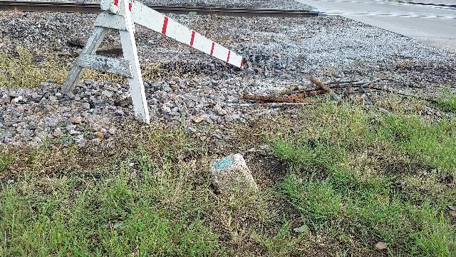
This bench mark was one of my high priority ones to fill a huge gap for the GPSonBM program. Railroad removed an old signal building at this crossing. The tire tracks were fresh when I arrived.
 .
.
We did a boundary survey about 20 years ago for a new orchard. Every section corner, 1/4 corner, and 1/16th corner was monumented with an iron pipe and brass cap stamped Washington State Reclamation Service 1921, they were part of a huge survey by WSRS, for an irrigation project under the overall control of USBR. Fast forward about 6 months, we’re back on site to stake the tree rows, and every single moment is torn out, and the cap is cut off of the pipe with a hacksaw. After a few days we noticed one of the irrigation guys had a belt buckle made of one of the caps. Turns out the whole irrigation crew thought they were pretty cool, so they all tore them out to make belt buckles out of them. We turned them in to the board but I don’t think much came of it. They are all remoumented now based on our original ties and accessories, all are Berntsen A1 mons with my dad’s number on them, positions preserved but the historical nature of the originals is long gone. We did find the flared bottom of about 1/3 of the pipes when digging to set the new ones, and one of the original stones from the GLO. They’re in the holes under the new mons. Some irrigation guys somewhere probably still have some extrememly valuable belt buckles that they can’t possibly understand like we do.

In the mid 1980s US 59 was widened.
A few miles north of Queen City, Texas one of the few remaining original Headright Boundary still intact with cut stone monuments and witness trees at each end with many original trees along the entire boundary were labeled “DO NOT DISTURB & KEEP AS NATURAL” on the plans of the Federal Funded project.
It would have been in the center median of the completed project.
However, all was completely destroyed.
Some of the DOT personnel disappeared during and after the project was completed.
0.02

My story is very minor compared to these. Did a simple one lot survey. Less than 30 days later I had another job in the same block. Three out of four of the bars set less than 30 days earlier were easily found. Where the heck is number four? Then I saw the new gas service line running to the house. The trench was only four inches wide but must have been centered directly through the bar. Never did find the bar. The probably saw the flag and decided it was an indicator of where to run the line.
How close are you to US 59. I’m a mile and a half.
Long way from Laredo, TX to somewhere on the northern border of Minnesota. Just for kicks I would like to fly to Laredo, rent a car, drive to the other end and, then, probably hitchhike somewhere to fly home. Supposed to be 1911 miles in length.

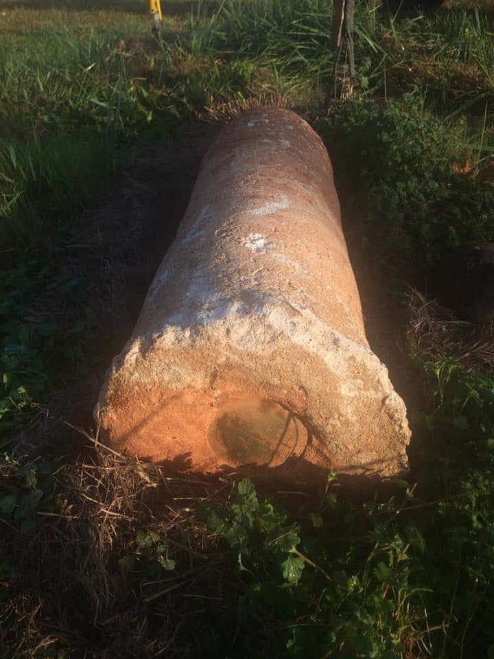
This monument must have just been in the way. Not sure which utility took it out. The witness post is still standing undisturbed.


Log in to reply.