
Activity Feed › Discussion Forums › Strictly Surveying › Oldest monument?
Oldest monument?
Posted by shildebrand on February 14, 2020 at 3:15 pmwhat is the oldest monument you’ve found / collected?
mine was northern Manitoba it was done in 1951.
holy-cow replied 4 years, 2 months ago 23 Members · 27 Replies- 27 Replies

Wood Post Section Corner set in 1854 or 1855, found mound of stones w/ [dead] Bearing Tree.
Loyal

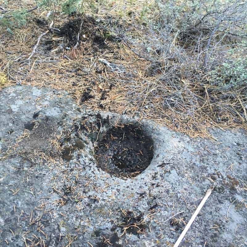
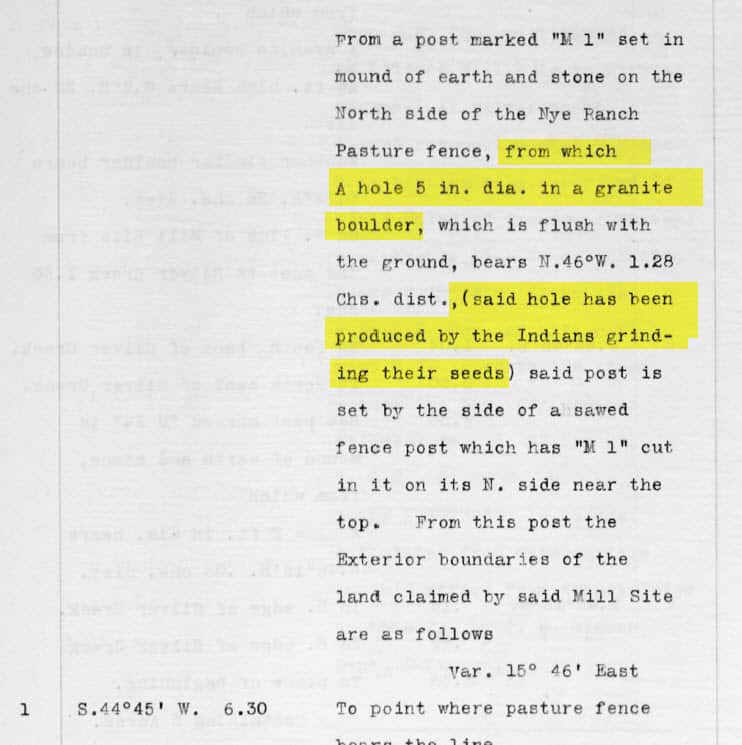
Mine was an accessory to a silver mining claim corner that was originally staked out in 1876. The accessory was MUCH older than that though, possibly by a 1,000 years or more.

Mine was “Ellicott’s Rock” on the banks of the Chattooga River as the corner of Georgia, North Carolina and South Carolina. The date carved in the rock was 1812.
Andy

Not quite what you’re asking, but I’ve seen the Mason and Dixon “star gazer’s stone” which was set in 1764 as the azimuth mark for their observations prior to running the line.
https://en.wikipedia.org/wiki/Star_Gazers%27_Stone
.
found corner accessory marked in 1790’s, search this board as there was a couple of similar threads years ago

“The Great Rock”. The rock itself has been there for around 15,000 years since the receding glaciers dropped in there. It was first mapped as part of the Beekman Patent sometime in the early 1700’s.

A number of 1879 monuments, I’m thinking the farthest one to the east would be the oldest.
- Posted by: @tomchurch
“The Great Rock”.
I suppose this rock:
https://books.google.com/books?id=dkg9AQAAMAAJ&pg=RA1-PA165#v=onepage
. 
 -All thoughts my own, except my typos and when I am wrong.
Quite a few stones set in 1865-1866. The only thing older around here would be original standard parallel monuments and Indian treaty boundary monuments. Not certain I have ever recovered an original of either variety.
Technically speaking, in a few cases a billion year old bedrock was used for a good place to chisel an “X” in 1865.

Besides LWP Section Corners and Bearing Trees, VISTA BUENA 2 1870, Cross in Granite Post set at base of bluff at Capt. Ware’s widow’s house.

1870s era stones found while at work.
ive visited District of Columbia boundary stones in Alexandria, those are early 19th century I think.

Station “Hawe’s Hill,” copper bolt set in ledge by Simeon Borden or one of his crews, 1832. NGS PID MZ1504. The data sheet says monumented by the US Survey of the Coast, but that is incorrect; it was monumented as part of the Borden survey.

While others had ‘found’ it well before my time; since it was the “first” one set, it is the oldest monument (1870) in Oklahoma I have laid my hands on.

Does anybody recognize our old friend in the photo?

“Muzzy Dam” was called for as a corner in a deed. When I found the dam, it was only half built out of field stones. One of the locals told me that the dam was half built when the owner/builder went off to war and never completed the project. I checked in “History of the Town of Hubbardston” by John Murdock Stowe and found that William Muzzy moved there in 1773, and died in 1830 at the age of 97. He only begat daughters, and the name Muzzy dropped out of the town records as they married off. I’m guessing the dam was built just prior to the War for Independence, as he would have been 79 years old at the start of the War of 1812, and not likely to have gone off to fight.

Survey I was doing for school districts up in Dunstable and Groton. MA (can’t remember exactly which school it was) around 1987-88. Can’t recall the name of the survey that I was retracing, but he had a habit of chiseling the first letter of his last name ‘B’ on the stone wall and put a drill hole in the center of the lower portion of the ‘B’. I seem to recall it was set in the latter part of the 1790’s. It was a very cool find.

This is by far my oldest. From the Penna Canal ~1830. Also found some original stones from 1947 in my hometown can’t find the pics though.
@peter-lothian Very cool!
@ric-moore Cool indeed!

It was from about 1792, but I no longer recall the exact date. It is an old iron bar set in a square of bricks at the top of The Great Falls in Paterson, NJ. The bar was one of the key points to control the raceways (canals) that took water from the Passaic River, dropped over a wheel, and after passing through the upper, middle and lower raceways, returned to the river. The water powered the mills, first cotton, then silk, that were built along the raceways. There was also a marble block, a little larger than a standard brick, set in the face of a sandstone cliff behind the Colt revolver mill, but that was a little newer; probably early 1800’s. All part of The Society of Useful Manufacturers established by Alexander Hamilton.
I did this as part of a survey to create a park at the raceways. We were following surveys from the 40’s and 50’s that were generally run on parallel offsets by Charlie Geiger, who did his comps in the fieldbook, in the field. I worked on his stuff for about 4 years and I never found a mistake. Tight stuff, considering the time.
Lots of history in that part of NJ.
Ken


Log in to reply.