
Activity Feed › Discussion Forums › Strictly Surveying › NGS recovery notes…
NGS recovery notes…
Posted by john-hamilton on June 20, 2018 at 1:19 pmIts nice to be able to download the shape files for each state, updated monthly. I can do queries based on datum tag (if 2011 then it is in the NSRS as GPS), elev order, and satellite use, for example…
Until you get one of these…
 bill93 replied 5 years, 10 months ago 6 Members · 9 Replies
- 9 Replies


John,
Haven’t you seen the photo of David Doyle’s GPS occupation of the Washington Monument. You just need some scaffolding and one of those special jig and you golden.

Oh, I am sure it IS open to the sky for satellite visibility.
I have also seen the same “good for GPS” on benchmarks set vertically. Yeah, I can hold a handheld beside it, so it is suitable for satellite observations.
Actually, in the old days we had to set companion stations (“azimuth marks”) for all of the photo control we were setting around here, late 80’s. So I got permission to set a GPS station on top of the University of Pittsburgh Cathedral of Learning. It was already an intersection station in the NSRS (KX2072), but I set a point there on the roof and then tied in the center of the radio antenna in the center to use as a backsight for multiple stations…

yeah- sometimes the actions of the geocachers aren’t helpful-
https://www.geocaching.com/mark/
Look here for Q 71 PID QZ0035…. this mark is on the priority list.
…at least they noted what they did…..
Here is one of my favorites…it is a triangulation station, I GPS’d it back in 1988 for a bluebook project.
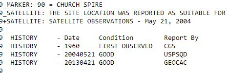
KY3089 STATION RECOVERY (2008)
KY3089
KY3089’RECOVERY NOTE BY INDIVIDUAL CONTRIBUTORS 2008 (DH)
KY3089’NGS REPORTED COORDINATES N 40 DEG 21.216 W 080 DEG 00.990 (NAD 83)
KY3089’ARE INCORRECT.
KY3089’THE ACTUAL COORDINATES ARE N 40 DEG 21.219 W 080 DEG 00.994 (NAD 83)
KY3089’SEE TINYURL.COM/6KNOTQ FOR PHOTO SHOWING THE INACCURACY.
KY3089’THE BENCHMARK POSITION HAS CHANGED.
KY3089’IN THE DOCUMENTED HISTORY 25-JAN-1989, ‘HIT BY MACHINERY AND PART OF
KY3089’THE DISC HAS BEEN SHEARED OFF. THE MARK MAY BE SLIGHTLY OUT OF
KY3089’POSITION’
KY3089’PLEASE EITHER UPDATE THE COORDINATES OR MOVE THE BENCHMARK BACK TO THE
KY3089’CORRECT LOCATION.
KY3089I made the 1989 report, and I said that the RM was hit by machinery, not the station mark.
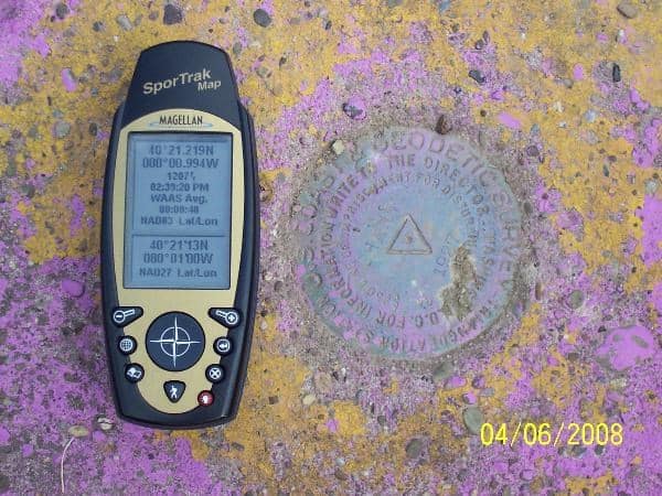
Here is the “photo showing the inaccuracy”…
- Posted by: John Hamilton
Here is one of my favorites…it is a triangulation station, I GPS’d it back in 1988 for a bluebook project.
KY3089 STATION RECOVERY (2008)
KY3089
KY3089’RECOVERY NOTE BY INDIVIDUAL CONTRIBUTORS 2008 (DH)
KY3089’NGS REPORTED COORDINATES N 40 DEG 21.216 W 080 DEG 00.990 (NAD 83)
KY3089’ARE INCORRECT.
KY3089’THE ACTUAL COORDINATES ARE N 40 DEG 21.219 W 080 DEG 00.994 (NAD 83)
KY3089’SEE TINYURL.COM/6KNOTQ FOR PHOTO SHOWING THE INACCURACY.
KY3089’THE BENCHMARK POSITION HAS CHANGED.
KY3089’IN THE DOCUMENTED HISTORY 25-JAN-1989, ‘HIT BY MACHINERY AND PART OF
KY3089’THE DISC HAS BEEN SHEARED OFF. THE MARK MAY BE SLIGHTLY OUT OF
KY3089’POSITION’
KY3089’PLEASE EITHER UPDATE THE COORDINATES OR MOVE THE BENCHMARK BACK TO THE
KY3089’CORRECT LOCATION.
KY3089I made the 1989 report, and I said that the RM was hit by machinery, not the station mark.
Here is the “photo showing the inaccuracy”…
I guess we all know what (DH) stands for…..
Good one!

Here’s one in south Louisiana
AH7270'WEST-SOUTHWEST OF THE NORTHWEST END OF THE PIPE, 6.8 M (22.3 FT)
 AH7270'EAST-NORTHEAST OF THE 1ST ELBOW SOUTHWEST OF THE NORTHWEST END OF THE
 AH7270'PIPE AND 0.3 M (1.0 FT) NORTH OF A WITNESS POST.  NOTE--WEAR
 AH7270'PROTECTIVE CLOTHING AND HAVE MOSQUITO REPELLENT AS THE MOSQUITOES ARE
 AH7270'VERY BAD HERE.
“Please either update the coordinate or move the benchmark back to the correct location”
Oh my!!!
hehehe

Yes, some hobbyists don’t know what it is they don’t know.
A few reports from employees of big surveying and engineering companies will raise your eyebrows, too.
I saw one that reported Good on a 1934 disk but said the stamping said Reset. Ahem, … I found the bridge was gone and the reset disk was in a poured post. He must not have read the description very carefully.
And the one on a Harn that gave his measurement (how long a session or rtk?) in SPC and lat-lon. The lat-lon was degrees off and turns out to be the 0-0 point of the SPC zone. Wouldn’t you expect someone paid to do the work would know within 2 degrees of the lat-long they were at, or maybe compare to the data sheet they are trying to update?
.


Log in to reply.