
Activity Feed › Discussion Forums › Strictly Surveying › Location of the Sun
Location of the Sun
Posted by true-corner on July 7, 2020 at 3:01 amWe were setting off fire works with the Grand kids and it was Sundown, there was an orange glow in the Western Sky. I pointed to it and said that’s due West. My wife and 30 something son said no way. The sun sets due west only if we’re at the equator. Huh? Okay my point is that the sun sets due west regardless of the season and regardless of latitude. What do you guys say?
MightyMoe replied 3 years, 9 months ago 22 Members · 33 Replies- 33 Replies

Negative.
😎

The sun sets due West of somewhere between the Tropic of Cancer and the Tropic of Capricorn every day of the year. The State of Hawaii and the Commonwealth of Puerto Rico are within that range. The Sun sets due West of a qualifying location at most twice a year. I might assume you have never seen an ephemeris or taken a Solar shot.
Paul in PA

Most people know that the Sun “rises in the east and sets in the west”. However, most people don’t realize that is a generalization. Actually, the Sun only rises due east and sets due west on 2 days of the year — the spring and fall equinoxes! On other days, the Sun rises either north or south of “due east” and sets north or south of “due west.”

@paul-in-pa No, I’ve taken plenty of solars but not at sunset or sunrise. I knew it hangs in the southern sky but I always thought at sunrise and sunset it was due east and west. My bad, only at spring and autumn.

Agree with Mike Marks
The sun rises north of east and sets north of west in the summer, and rises south of east and sets south of west in the winter in the USA.

Everywhere in the world the sun rises and sets on very nearly astronomic east and west on the equinox.
Views are important to property owners and architects. It can be most of the value of a lot. I add a view diagram to most topos. I point the scope at the feature, turn on reflectorless, hold my hand in front of the scope and shoot it. One time an architect asked me to add sunrise and sunset to the view. I thought “what a PITA” but found a web site somewhere that had the info I needed. It varies a little based on your latitude and now it only changes if my north rotation is based on an existing boundary that’s magnetic north.

Right now it sets a long ways north of west and comes up a long ways north of east to make really long days. Not quite as long as about 16 days ago.

https://www.esrl.noaa.gov/gmd/grad/solcalc/calcdetails.html
Go to this page and download the spreadsheet. You can enter your Lat Long and see the results for any day of the year.
For my area, the azimuth at sunrise will vary from 62 degrees to 116 degrees summer to winter

I got into this last spring when we went Solar.
setting the orientation of the panels East – West and the tilt is kinda important, but does not need to be precise…but still, it matters.My installer, Electrical Engineer and a brilliant man, relied on his software and he just did not understand.
after a few conversations he finally declared himself as “Intellectually Lazy” (never tried to figure it out) and I admitted that I was so deep in the woods that it was hard for me to explain the basics.Now, I am preparing myself to teach these concepts to my grandkids.

Teach them kids up good. I try to cram as much of that kind of stuff into my grandsons as I can. Lord knows what will stick and what won’t. Just a few weeks ago I let them in on the “D-O-C” phases of the moon.
As far as the position of the sun when rising or setting; growing up where you could see the west or east horizon at sunset or sunrise must have been the key for me.

This relates to the classic maritime navigation concept of “amplitudes.” An amplitude is the angle along the horizon between the observer’s east or west point of the horizon and a rising or setting celestial body. Amplitudes were (still are?) used for checking compass errors (it’s easy to take a compass bearing of a celestial body as it’s rising or setting, versus when it’s high in the sky). The formula for amplitude is simple:
sin(Amplitude) = sin(Declination of body) / cos(Latitude of observer)
That formula assumes the body is on the celestial horizon; there are small-ish corrections for reference to the visible horizon.
See “American Practical Navigator” Volume 1 page 271 and Volume 2 page 6. This is a great book for learning about positional / spherical astronomy, and many other topics too. It’s commonly known as “Bowditch” after its author (as in Bowditch Rule / Compass Rule traverse adjustment), first published in 1802 and still being revised as of 2019. Available as free PDFs from the National Geospatial-Intelligence Agency:

The dependable east-west reckoner is Orion, or more specifically. Mintaka, the western-most star in his belt. It always rises due east and sets due west, not always so’s you can see it, though.
In my early-rising days, I used to look for Orion before dawn in September-October when I walked to the end of the driveway to pick up the paper. Now I sleep late and read the paper online, but I’m going to change ………… someday.
Yes indeed, the declination of Mintaka is South 00º 17″ 57″, or pretty close to zero. Hence, its amplitude (see my previous comment in this thread) is pretty close to zero.
 Posted by: @mathteacher
Mintaka, the western-most star in his belt. It always rises due east and sets due west,
At declination 17 arc minutes south (current, as opposed to 2000.0, according to Stellarium) and magnitude 2.4, it certainly is the closest easily identified star for east-west.
Another close E-W one is Sadalmelik (Alpha Aquarius) at 13 minutes south, magnitude 3, and rising/setting several hours different from Mintaka which might be more convenient in some seasons, but it is much harder to locate.
.That’s good info. Our house faces North-South and in the summer, the sun setting in the Northwest can really heat up our living room. It’s a connection to the outside from the inside, which is good in these times.
Many years ago, I worked in a building on a 40-acre campus with a lake. Later, I was drafted up to the holding company which was housed in a 17-story building downtown.
My outside exposure changed from trees and bees to sun and moon, from dirt and grass to asphalt and concrete. Something new to study, but I missed the old digs tremendously.

It takes roughly eight minutes for the Sun’s light rays to travel to Earth. And the refraction in the low atmosphere works out so you are seeing the Sun about eight minutes before it is truly above the horizon. Do these two factors work to cancel one another out ?

I have a neat little app called “SunSurveyor” that has a very cool graphical display of the suns position, along with some other really cool stuff…

I like this: https://www.timeanddate.com/sun/usa/las-vegas?month=1
You can set your location in this app. Here is a sample screen capture:
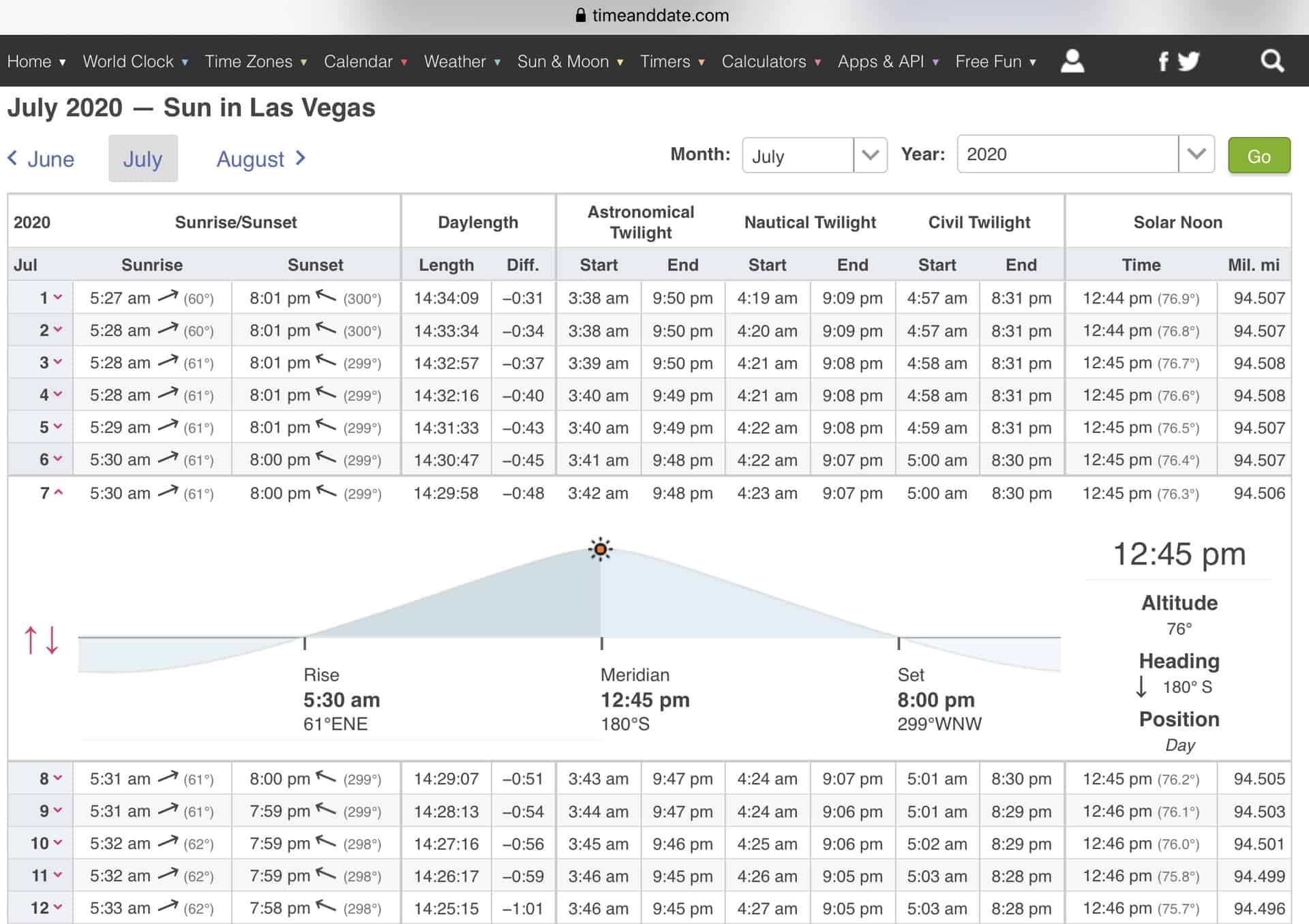
there are other aspects just go to the home page.
@rj-schneider That’s a good question. Spherical astronomy catalogs and ephemerides (for celestial navigation, surveying, observational astronomy) give coordinates of celestial bodies as they appear now from the center of the Earth, not where they will be or were plus or minus the light travel time. Thus the light travel time doesn’t enter into the typical sight reductions (but it is important if you’re the Jet Propulsion Laboratory navigating a spacecraft to another planet). Corrections for atmospheric refraction are still applied to convert to or from apparent (observed) positions.
The speed of light does enter into the reductions in another way, due to an effect called “aberration.” The apparent position of a celestial object is displaced towards the observer’s direction of motion, so over the course of a year, as the Earth goes around its orbit, the positions of objects in the sky shift to and fro slightly (about 20 arcseconds).
There are other effects that enter into sight reduction, such as annual parallax, topocentric parallax, dip of the horizon, etc.
The Bowditch book that I mentioned earlier in this thread is a good source of explanations. Another nice resource, although I’m not as familiar with it, is Henning Umland’s “A Short Guide to Celestial Navigation,” which can be downloaded from: https://www.celnav.de/page2.htm

Think of this, there are places on the earth today where the sun never sets, and other places where it won’t rise. As the year progresses it will set and rise almost north near the north pole and the points of rise and set will slide south until it doesn’t show at all.

Log in to reply.