
Activity Feed › Discussion Forums › Strictly Surveying › Homestead House
Homestead House
Posted by ridge on January 16, 2018 at 3:15 am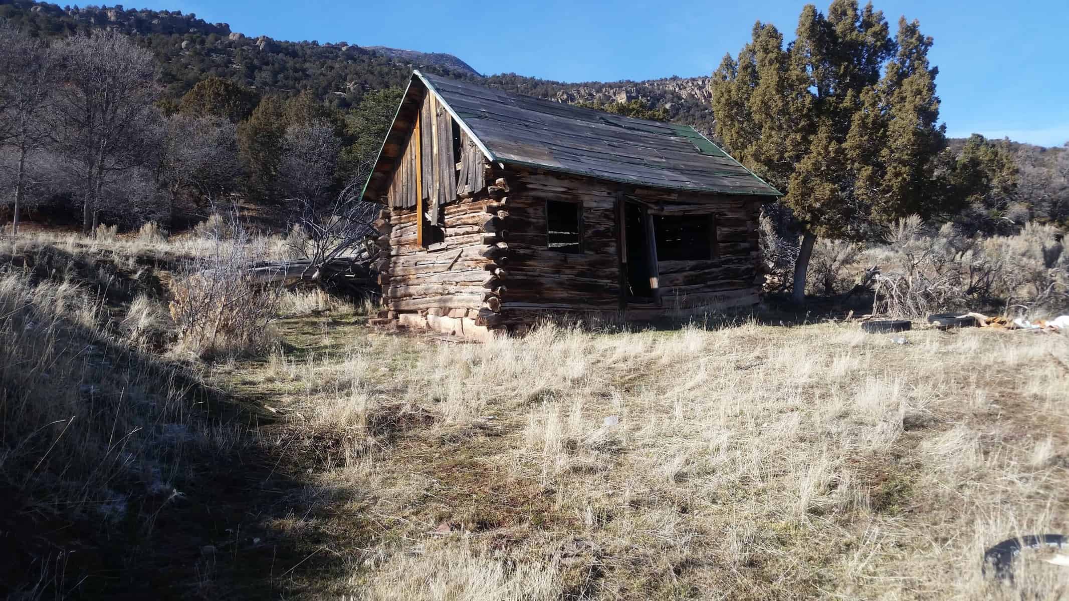
Working new little 4 lot subdivision which is pretty much on a 640 acre homestead patent from 1927. I speculate that this is the homestead home. Hasn’t been used for awhile. Found several GLO caps from a 1914 resurvey and completion survey of the township. The resurvey tracted some parcels from an earlier GLO survey, so more than the normal amount of corners by the GLO. Section 24, T 15 S, R 2 E, SLM.
RADAR replied 6 years, 3 months ago 11 Members · 18 Replies- 18 Replies

Were there any passing calls in the notes for the house or does it appear the house was built after the survey?

I haven’t been able to download the notes yet, just the plats. Sent an Email to the BLM yesterday, today holiday, hope to hear back from them tomorrow. Seems like about 20% of the time there is some glitch with the notes on the website, but they are real good to fix it. I must be the first one to try to download the notes and discover the problem. I really do need to read the notes!

Homesteading in 1927 must sound bizarre to our brethren in New England.
 Posted by: holy cow
Homesteading in 1927 must sound bizarre to our brethren in New England.
The various “Homestead Acts” were in effect until the passage of FLPMA in 1976 (1986 in Alaska). Although not particularly common after the mid-20th Century, I run into some pretty “recent” Homestead Patents here in the Great Basin.
Loyal

I ain’t got no home. -Woodie Guthrie
 Posted by: Dave Karoly
I ain’t got no home. -Woodie Guthrie
- Posted by: Peter EhlertPosted by: Dave Karoly
I ain’t got no home. -Woodie Guthrie
And as through your life you travel,
Yes, as through your life you roam,
You won’t never see an outlaw
Drive a family from their home.  Posted by: LoyalPosted by: holy cow
Homesteading in 1927 must sound bizarre to our brethren in New England.
The various “Homestead Acts” were in effect until the passage of FLPMA in 1976 (1986 in Alaska). Although not particularly common after the mid-20th Century, I run into some pretty “recent” Homestead Patents here in the Great Basin.
Loyal
Spending a number of years as a boy in Buena Vista, CO I remember there were several places up in the woods we (and all the adults) referred to as “homesteaders”. I had several classmates that hailed from some of these remote “homesteads”.
There are a number of different “Homestead Patents” such as exchange, reclamation, forest, etc. I did a quick lookie at Homestead/Original Entry Patents only in Chaffee County and the most recent I found was 1952. Most were in the 1890 to 1930, only a few after that.
Here’s a copy of that 1952 patent:

Most of the Homesteads I’ve encountered in NW Colorado have been resubdivided since they were first surveyed in the early 1900’s. The ones I’ve seen are all the Lincoln – 160 acre variety (too small to support slavery, one of Lincoln’s brilliant legislative strikes against slavery). three common traits I’ve detected: Most are very well surveyed with stones, most still have the required 12×12 cabin, or remnants thereof, and most are in very remote areas, those people were dang tough.

Warren, that is an interesting fact about Lincoln/slavery and 160 acres. Makes sense, I never heard that before. Jp
Paden’s link refers to a Lot bigger than 80 acres. That’s one BIG lot.

Done two or three surveys of historic Homesteads and a few more Donation Land Claim Act acquisitions. It was long ago, but I recall the applicant had to make improvements including housing and working the land for a period of years before the patent was granted.
By the time I got there (100 years later) the patent was perfected and what was empty land had been turned into valuable farming land and was undergoing subdivision. The actual location ignored the GLO system given that in many cases the land was claimed prior to Federal Survey, so if encountered during survey was sequestered out of the township-range-section geometrics, much like the Mexican Land Grant exclusions in California.
Interesting surveying, based on original occupation, GLO records showing the exception from the Cadastre, and contemporary surveys purporting to show adjacent parcels locations based on simple section breakdowns. We’re talking 320 & 640 acre parcels here so lines were miles in length with no remaining original monuments. I recall using a Tellurometer to measure 6 mile lines between valid original monuments in an attempt to do a lost corner proration to establish lost section corners.
It was an off and on all summer survey. Finally had my “mathematic” solution ready for criticism. Funny thing was even though the record was wildly not in conformance with on the ground occupation most (not all!) neighbors acquiesced to the occupation lines. My “ah-ha” moment was when I met with farmer “X” and pointed out my flagged stake was 150′ east of where the dividing line between cultivated fields was. He marched me over 150′ west and showed me a horse drawn plow nailed to a perimeter walnut tree which he claimed had been there for 60 years and had me eye a line north to a rock bluff a mile away where there was a cut road serving both fields. Cultivation was within feet of that straight line.
He was an old tobacco spitting farmer and looked me right in the eye and said he could care less what my newfangled gizmos and blather about section corners, etc., meant. He said if I wanted to move the line 150′ he and his neighbor would ignore it and continue to live in harmony. In essence, f**k me.
I didn’t record that survey, although it was a magnificent analysis of record vs. recovered section corners within a Township, although some pecadillos concerning County Road R/Ws were recorded to protect the public resulting in minor eminent domain judicial actions.
Supreme Court Script Patent
This patent was to one on my Great Grandfathers. Not sure what a Supreme Court Script Patent is. This grandfather was an emigrant from Denmark.
Authority : March 17, 1842: Scrip or Nature of Scrip (5 Stat. 607)
It is an historic stroke of luck – out of many – that Lincoln tried his hand at surveying before giving law, then politics a try. He fought against slavery using several weapons – speeches, war, and politics – and drew on all his past occupations in the fight. His time as a surveyor gave him a perspective on size of land. he had a good grasp on what the 37th parallel meant when his government in 1850 “agreed” to limit slavery to south of that line – in 1863 he commissioned the placement of what is now the four corners monument, using legislation as a weapon to contain slavery, and to expand freedom north of that line. the Homestead Act of 1862 invited any man – of any color, including freed slaves – EXCEPT any confederate, to settle the west in 160 acre homesteads, that in and of itself would not allow slavery by virtue of size – and in 1862 the Union had little confidence in the outcome of the war .
I forgot to add, that when Lincoln was contemplating how to prevent slavery from expanding to the west, and the war was not going well, he took advantage of the fact that all the southern representatives had seceded, and therefore were not voting on Union legislation. Therefore, the Homestead Act of 1862 passed with the anti-slavery republican majority – when those southern votes would have defeated that act if he had tried prior to 1861.
- Posted by: Rankin_File
Were there any passing calls in the notes for the house or does it appear the house was built after the survey?
About 1/2 way down page:
14.20 Thomas Reece’s house bears W. 5 links.
Good reason to homestead as the house is on unpatented land at the time of the survey. Not very far, 5 links.
Where would the call be to, looks like middle of house to me from kml into Google Earth. I’ll have to shoot the house next time I’m out there. I just took the picture as I walked to a corner I wanted to find.
 Posted by: LRDay
…Where would the call be to, looks like middle of house to me from kml into Google Earth. I’ll have to shoot the house next time I’m out there. I just took the picture as I walked to a corner I wanted to find.
I went to a seminar on the 2009 Manual; presented by Bob Dahl and Jerry Broadus. I remember them saying that GENERALLY, measurements to cabins and other man-made structures were made to the nearest corner to the referenced line…
Your mileage may vary
I hope everyone has a great day; I know I will!
Log in to reply.