
Activity Feed › Discussion Forums › Strictly Surveying › Colonial Land Surveying
Colonial Land Surveying
Posted by foggyidea on July 25, 2018 at 1:54 pmWe do have it so easy in Colonial America 🙂 No pesky Manual of Instructions to make our decisions for us, lol, or difficult math with back azimuths different than the foresight…
And we get the pleasure of “following it the footsteps” of the “giants” that walked before us!
Such as this little disclaimer I found on a plan done by a very reputable surveyor kind of early in his career,
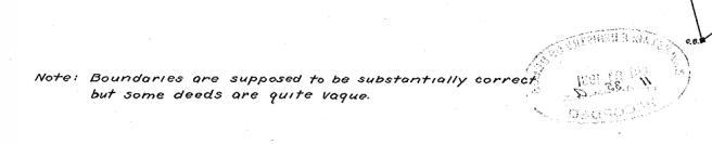
Over the years that surrounding property, as well as locus, has been surveyed and divided again and again, but since I am working for the heirs of the original purchaser (approx. 1930) I am left with a remainder pieces ripe with junior/senior conveyances, and even some simultaneous conveyances through some subdivisions…..
Don
Brian Allen replied 5 years, 8 months ago 24 Members · 44 Replies- 44 Replies


There seems to be a general misunderstanding among colonial state and Texas surveyors about the nature of surveying in PLSS states. As someone who is licensed in all three I can assure you that to survey correctly in PLSSia is just as complex, as the colonial states.
I think the misunderstanding comes from two things:
1. You are more likely to encounter a boundary that requires less complex decision making in the PLSS states. When the system works as Jefferson intended things are great, but that is rarely the case, as a result PLSS state surveyors have to understand both the failings of the PLSS system and metes and bounds descriptions (yes the PLSS states are full of them).
2. It is easier to survey incorrectly in PLSS states. The manual does not tell you what to do, unless you are preforming an original survey or need advice drafting a BLM plat or writing BLM notes. It is however, easy to take any one part out of context and believe it is a commandment. The manual is not any more of a instruction manual for private surveyors as any of the popular boundary surveying text books. There is a lot of important stuff in there, but if you believe that it tells you what to do, you don’t understand it. In the western PLSS states the added complexity of applying federal law and state law as appropriate, sometimes for the same line, also has to be dealt with.
It is possible to restrict yourself to easier surveys if you only survey in a non mountainous rural agricultural area were all the deeds are based on aliqout parts, the local standard of surveys is low, and you avoid riparian issues, but a colonial state surveyor can restrict themselves to easier surveys too, by only doing mortgage surveys in residential subdivisions.
I have on my desk now, a legal description for a parcel in a PLSS state that is composed of 120 separate metes and bounds deeds with multiple gaps and overlaps, public domain boundaries, acquired federal land boundaries, improvements that are hundreds of feet off of deed lines, accretion to be apportioned, erosion and avulsion. I also have a description that is a lot and block of a surveyed subdivision in a non PLSS state.

As a former CFedDs surveyor, and 35 year colonial surveyor I agree with everything that you said. I was ‘joking’ in my post. Surveying isn’t easier anywhere. Every place is going to have it’s issues.
My post was poking fun at a predecessor from the early 1900’s that kind of described a common problem for us here on Cape Cod.

This is where surveyors get the shaft. We have to get it right, find all of the conveyances into and out of the subject parcel.
Yet all of the conveyances that came before were probably done with realtors and lawyers who all got paid way more than we do, without bearing the liability of accuracy in respect to the parcels that were being sold.
Just copy the old deed, and say that it’s subject to all conveyances, easements, restrictions, etc, and that’s it. But we have to actually nail all of those down or we get sued.
I’m fine with researching to get the locations correct, but we should have some way of limiting liability to what the current deed describes, not all of the reference deeds. (just ranting)


I do not see the difficulty in Survey something that is a square, where you have known places to look for corners, a manuel telling you how to Survey, and where everything is recorded in the courthouse, and most of the city and county laws match with what the manual tells you to do.
However based on plenty of the same questions from PLSS Surveyors on this site, that most Colonial Surveyors would never have a problem with it must be difficult.
 Posted by: Scott Ellis
I do not see the difficulty in Survey something that is a square, where you have known places to look for corners, a manuel telling you how to Survey, and where everything is recorded in the courthouse, and most of the city and county laws match with what the manual tells you to do.
However based on plenty of the same questions from PLSS Surveyors on this site, that most Colonial Surveyors would never have a problem with it must be difficult.
We tried to use Manuel but he kept taking siesta on the job.
 Posted by: Dave KarolyPosted by: Scott Ellis
I do not see the difficulty in Survey something that is a square, where you have known places to look for corners, a manuel telling you how to Survey, and where everything is recorded in the courthouse, and most of the city and county laws match with what the manual tells you to do.
However based on plenty of the same questions from PLSS Surveyors on this site, that most Colonial Surveyors would never have a problem with it must be difficult.
We tried to use Manuel but he kept taking siesta on the job.
Well Dave, I just spit coffee all over my desk! Too FUNNY!!
Robillarding: “Just copy the old deed, and say that it’s subject to all conveyances, easements, restrictions, etc, and that’s it.”
Admin’s Note:
Please keep things civil and refrain from attacking other users, even if you disagree with them.Now back to your regularly-scheduled thread.
Your friendly, virtual neighborhood Webmaster- Posted by: foggyidea
As a former CFedDs surveyor, and 35 year colonial surveyor I agree with everything that you said. I was ‘joking’ in my post. Surveying isn’t easier anywhere. Every place is going to have it’s issues.
My post was poking fun at a predecessor from the early 1900’s that kind of described a common problem for us here on Cape Cod.
Sorry, I know you weren’t trying to be dismissive of the PLSS. I was just trying to get in ahead of the inevitable “its just a square comments.”
- Posted by: aliquotPosted by: foggyidea
As a former CFedDs surveyor, and 35 year colonial surveyor I agree with everything that you said. I was ‘joking’ in my post. Surveying isn’t easier anywhere. Every place is going to have it’s issues.
My post was poking fun at a predecessor from the early 1900’s that kind of described a common problem for us here on Cape Cod.
Sorry, I know you weren’t trying to be dismissive of the PLSS. I was just trying to get in ahead of the inevitable “its just a square comments.”
What shape do you think the PLSS is?

What shape do you think the PLSS is?
I’ll answer your question with a question…what shape do you think a section is?

 Posted by: Scott EllisWhat shape do you think the PLSS is?
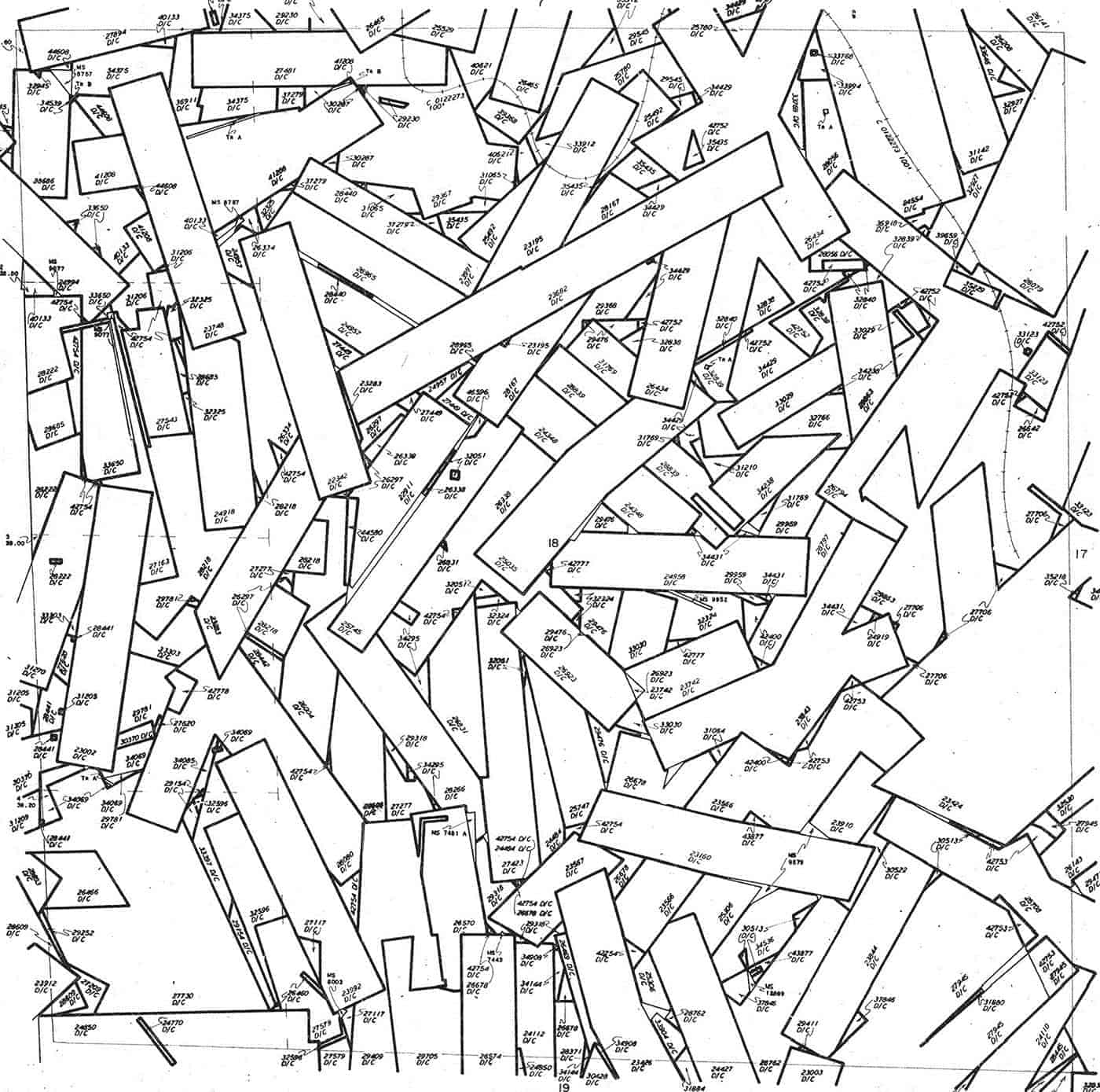
In case you missed my post from earlier this year Scott, here is a Master Title Plat Supplemental sheet for Sec. 18, T. 15 S., R. 69 W., 6th P.M.
I’ll leave the descriptions of the tract shapes in this one sq.mi. area to others. Maybe “simple, overlapping rectangles”? ?
 I hope everyone has a great day; I know I will!
There was a period between the wars that most everything around here was done purely with a magnetic needle and those descriptions are interesting.
Few of them actually mathmatically close very well.
Mostly they are simple to follow because the surveyors left some great metal monuments, large in size and must have taken a mule to drag to location.
Then you get to a boundary and the direction takes you totally out into the twilight zone where a boundary never went.
The distances of the boundaries work every time, some good measuring was done.
0.02
- Posted by: Gene KooperPosted by: Scott EllisWhat shape do you think the PLSS is?
In case you missed my post from earlier this year Scott, here is a Master Title Plat Supplemental sheet for Sec. 18, T. 15 S., R. 69 W., 6th P.M.
I’ll leave the descriptions of the tract shapes in this one sq.mi. area to others. Maybe “simple, overlapping rectangles”? ?
Gene
That is a mess, I would call that Rectangle Mineral rights game of pick up sticks shape.
- Posted by: Cameron Watson PLS
What shape do you think the PLSS is?
I’ll answer your question with a question…what shape do you think a section is?
Hmmm maybe call it Geoid model square.

I object to this being labeled Colonial Land Surveying, I came here thinking I might learn spmething.
Paul in Colonial PA
- Posted by: Paul in PA
I object to this being labeled Colonial Land Surveying, I came here thinking I might learn spmething.
Paul in Colonial PA
Well you can learn something…but it’s something about human nature, not surveying.


Log in to reply.