
Activity Feed › Discussion Forums › Strictly Surveying › 1882 US PBM
1882 US PBM
Posted by Norm on August 13, 2019 at 3:49 pm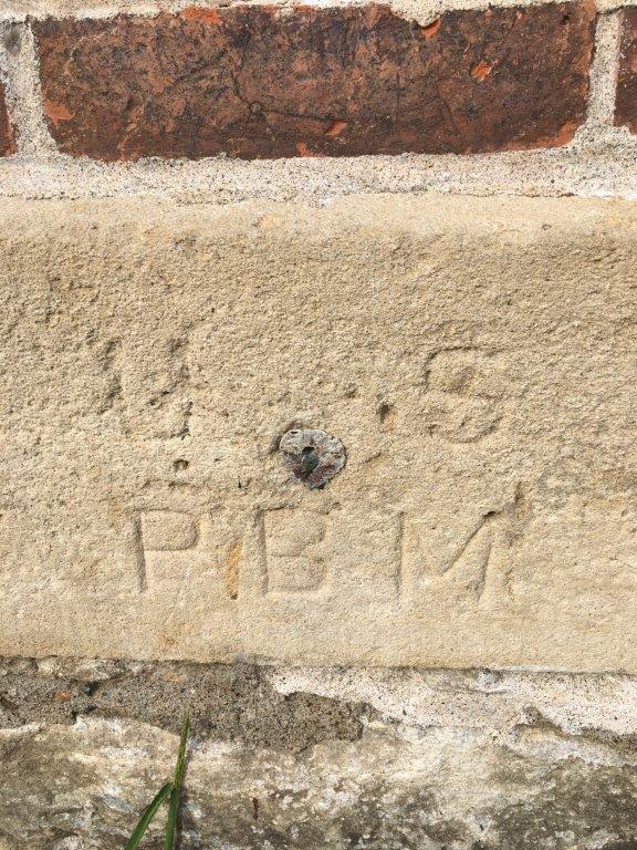 Norm replied 4 years, 8 months ago 5 Members · 12 Replies
- 12 Replies


Apparently use of meters wasn’t a problem in 1882.
The rods are 3 meters long, made of two pine boards with a T-shaped cross section, with an iron spur at bottom with a flat end, and a watch level by which to
hold it vertical. They are graduated to centimeters, and are read by estimation to millimeters. No target is used.Average daily run in miles for working days…….. 2.9
SAINT Louis, September 1, 1883.
SIR : I have the honor to submit the following report of the field work of precise levels from Grafton to Chicago. This work was done in three seasons, viz:
I. Grafton to Keokuk, 151 miles, done May 21 to August 30, 1881.
II. Keokuk to Fulton, 170 miles, done September 6 to November 25, 1882.
III. Fulton to Chicago, 170 miles, done May 2 to August 7, 1883.At Clarksville and Port Louisa the crossings were effected by simultaneous readings with two instruments on opposite sides of the river, the midwire bisecting a large target on the opposite shore. Sixteen readings were taken by each instrument, in sets of four, which were as follows:
1. Telescope normal, level direct.
2. Telescope normal, level reversed.
3. Telescope inverted, level direct.
4. Telescope inverted, level reversed.
Then each observer, with his instrument, crossed over, and the same was repeated. The longest readings thus taken were about 600 meters. Very good results were
obtained, the probable error being less than a millimeter.Maybe the new NGS river crossing method isn’t so new.

Many of the original surveyors were immigrants from the other side of the pond where meters were the standard.
Many a property was measured in meters with a meter tape or chain because it was what the surveyor had and everything was reported in the required unit of measure of the region they were working.
There were also the varying length of tapes and chains that were mixed up and used resulting in the report of the wrong distance of many original surveys.
In the late 1960s the surveyor that I first worked with only had vara tapes and we would compute the feet values when the State of Texas began its move from varas to feet in their reports.
Every construction site I’ve worked on all the plans were in feet and inch and we always used feet and tenth tape for the layout.
0.02

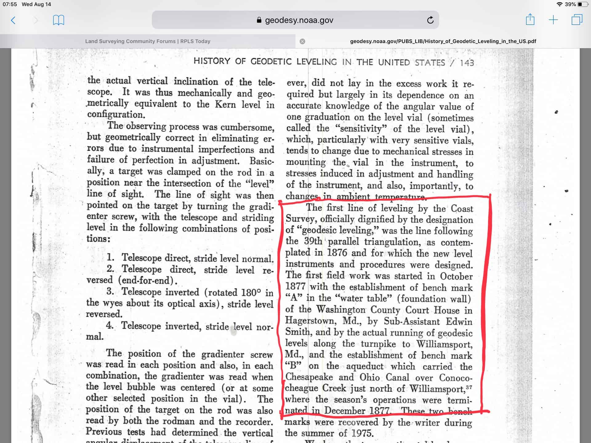
Here is the start of transcontinental leveling in the US: https://www.ngs.noaa.gov/cgi-bin/get_image.prl?PROCESSING=get_figure&IID=274994
And this history of geodetic leveling in the US: https://geodesy.noaa.gov/PUBS_LIB/History_of_Geodetic_Leveling_in_the_US.pdf
Reading the most recent recovery note on the point??s datasheet, I see mention that the site might not be suitable for GPS. Sheesh. I never trust these suitability reports. Clearly NOT usable for GPS.

Mike, I thought it was this one, which doesn’t have a GPS suitability line.
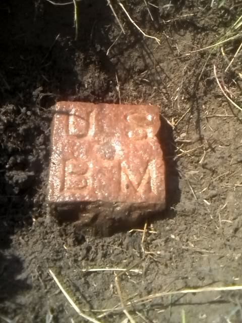
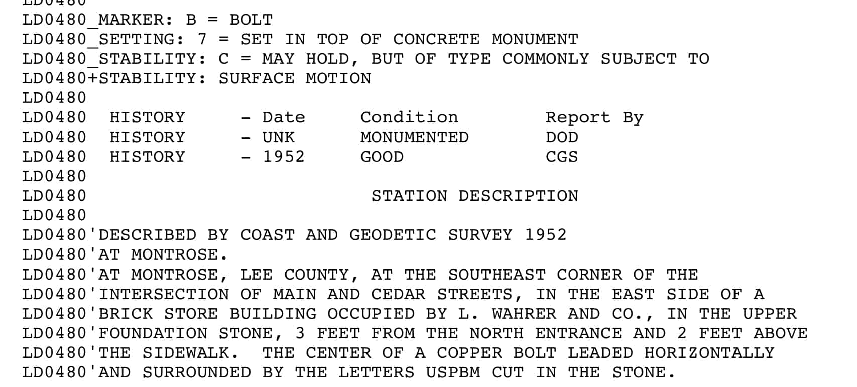
https://www.ngs.noaa.gov/cgi-bin/ds_mark.prl?PidBox=LD0480
Linebender is a bit further from home than I expected.
.Bill
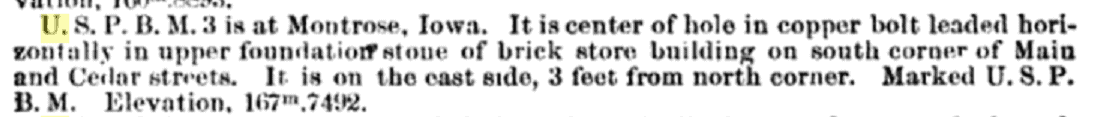
I can’t get too much further away and be in my work area – 60000 square miles give or take. The 1882 description is more accurate than the datasheet. The datasheet led us astray for a minute or two. That plus the owner had a bench (the kind you sit on) in front of the mark. Data sheet says AT THE SOUTHEAST CORNER OF THE INTERSECTION OF MAIN AND CEDAR STREETS. 1882 says on the south corner of Main and Cedar. It’s definitely not SE of the intersection. It is south or possibly SW. The data sheet lat/long put us 110 ft SE of the intersection. The mark is on the other side of the street. Also Main and Cedar run parallel in town nowadays. They don’t intersect. Note the difference in height. 167.7492m 1882 river datum vs 161.515m NAVD88. Looks like Mike one upped me by a few years on his BM.
No intent to one-up, I noted your image and recollected the historically significant BM A in Hagerstown, MD. The issue you mention with the description are not rare. I also recollect the effort to digitize BM descriptions as part of the NAVD88 project. The basic process was to use USGS quadrangle maps and level run information to plot the benchmarks then scale the position.
In my previous response I provided a link to a interesting history of US leveling. I captured the information pertaining to BM A below:
Mike
Appreciate the perspective and history. I found a BM A about 350 miles NW of the subject handsome hewn red granite BM a few years ago. I think it was for the Missouri River survey on a tributary. I have never been able to find any information on it other than the NGS data sheet.
 Posted by: @a-harris
Every construction site I’ve worked on all the plans were in feet and inch and we always used feet and tenth tape for the layout.
Really? I have never seen a set of civil plans in feet and inches.
-All thoughts my own, except my typos and when I am wrong.Every Internation Paper Co design are in feet and inches.
Done two malls that were, Longview and Texarkana.
Cason, Texas SWEPCO coal power plant was.
All these were that way because much of the designs are to fit prefab steel and other components onto the site.
While it is unlikely pre-modern surveyors gave much thought to maintaining uniqueness in designations, it is hard to trace information about the multitude of monuments designated “A” or something equally common.
I note inconsistencies between the description and the other fields on the LD0480 datasheet. It is hardly set in a concrete monument. Now that the datasheets are being updated by external parties, awareness of correct coding seems largely lacking. In this case it was an internal coder responsible.
I also note that this benchmark was last used in 1952 but participated in a 1991 adjustment highlights the problem with a national vertical network not maintained nor observed regularly. Additional evidence of the need for the new nationwide vertical datum.
Seems to me this would be worthy of a recovery and photo.
More than worthy. Also a Shared Solutions mark nearby with reference to the 1882 mark and a leveled height difference in the description. This will give the best tie possible from the cheap seats to the active and passive system.


Log in to reply.