
Activity Feed › Discussion Forums › Software, CAD & Mapping › Magnet Site/tools HELP!!!!
Magnet Site/tools HELP!!!!
Posted by Z.pandolfo on November 15, 2019 at 1:17 pmhello everyone,
I am extremely new to all of this and am still learning the in’s/out’s of GPS surveying/layout. The company I work for recently purchased Topcon MAGNET Site for me to learn how to produce project files and surface models for our own use in the field for our site Excavation division.
Here’s my issue…..
The cad file for the first project has been very easy to “clean-up” unnecessary data/linework. It already has a proposed surface model so other than clean up, all I needed to do was input control points and export to .Tp3 project file. After Getting out into the field and setting up my base station, localizing, and double checking line work I have discovered that the project is not aligned with the control points. What did I do wrong or how do I fix this might be a better question?
Thanks in advance
Zack
dave-karoly replied 4 years, 5 months ago 5 Members · 18 Replies- 18 Replies
 Posted by: @z-pandolfo
What did I do wrong or how do I fix this might be a better question?
Can you share any data with us?
MH
Can’t really tell from what you posted. Could be the CAD file is on a different coordinate system, could be you fat fingered something, could be you have a bad control point.

What data are you looking for? I can do my best to share
Also,
As i re-read my narrative I want to ad that I am only off 1ft in one direction and 2ft in the other. There are over 20 control points in the area, I am using the immediate 6 CP’s that I know the surveyor has confirmed. I’ve tried using other Cp’s, turning corrections on/off, adjusting my base station coordinates closer to the project but still to no avail. I’m willing to share any data necessary that will help figure this out. I’m eager to learn this stuff as I took AutoCad courses in HS and college but never went any further than that. Of course surveying is whole other ball of wax I know. I’m thinking something is off in the project file or I missed/forgot something in MAGNET
@z-pandolfo
Any data that would indicate either a random or systematic error. You said that you were extremely new to all of this. The best way to learn is to troubleshoot. You need to go through everything step by step. It wouldn’t hurt to set up some kind of test project to make sure your GPS field procedures are correct. You said you were off one foot in one direction and two feet in another. Check your project file parameters for proper scale factor, projection, etc. I’ve never used MAGNET Site, so I can’t walk you through it. I’ve never produced any surface models either. It all sounds very interesting to me. So, you use your RTK GPS only to verify line work? I assume your Excavation division uses machine control, so no staking necessary?
MH
You could be staking with an original raw data file that does not reflect the transformation data to match the site control.
In fact, there are many possible situations that could cause the situation you are encountering.

@z-pandolfo
Sounds like you need more training/support …. Upload your file from Pocket3d with the Localization (TP3 file) here so can try to help you.
With an error of that size, it could be a USft vs International Foot, NAD83 vs NAD83 NO_TRANS vs WGS84 translation. Could be many things, we are just guessing. Often on a large construction project, you don’t need a localization at all, just use a projection.
I had to compress the file. This forum wont allow direct tp3 attachments.
I totally agree on the more training part. I am eager to learn!!!! I’ve looked into some of the training that Topcon offers and will be beginning with that soon.
@z-pandolfo
From looking at your data, it appears you have a problem with your field procedures.
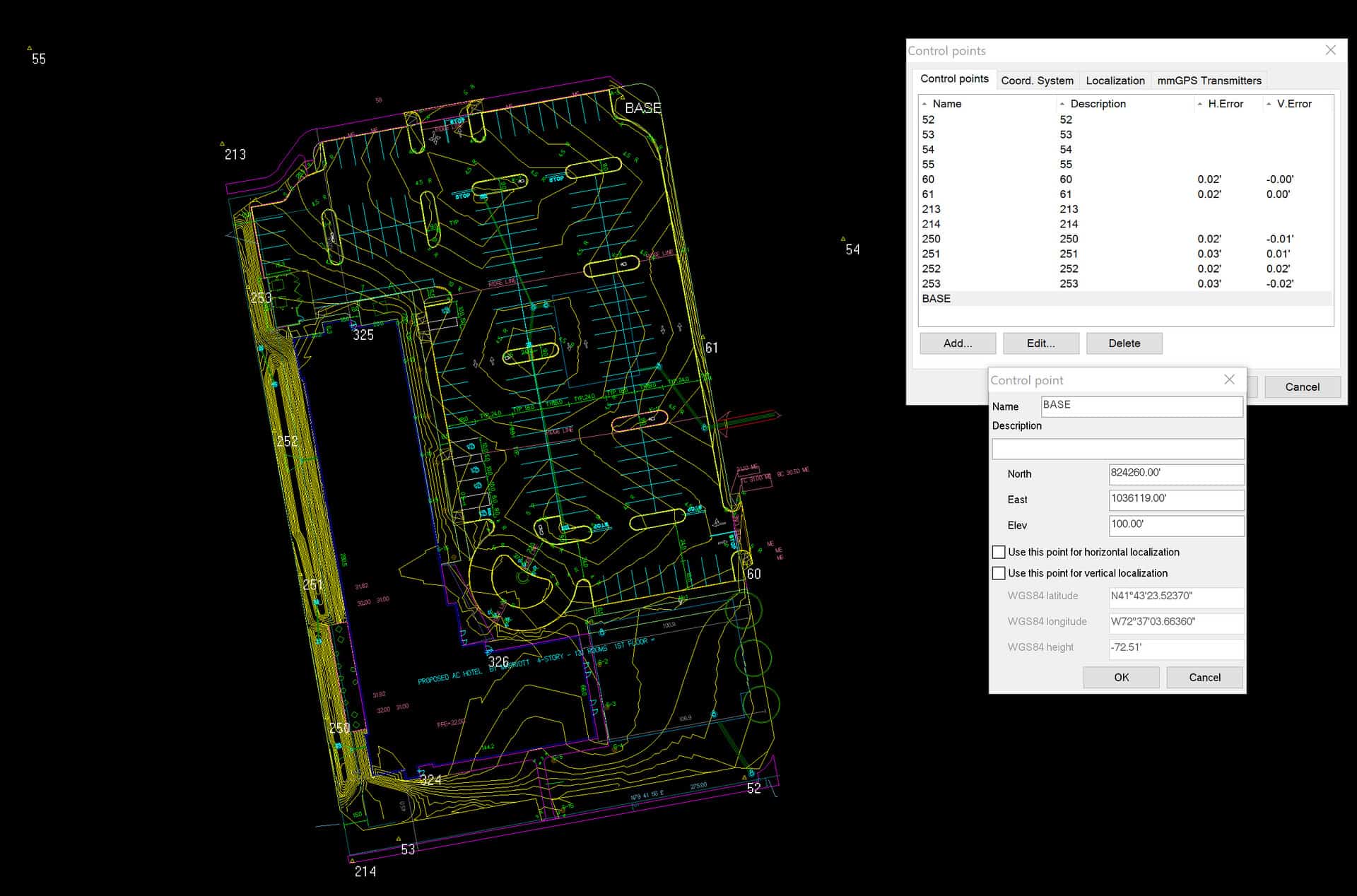
- Coordinates appear to be in State Plane datum, therefore no localization is needed. Try using the correct State Plain grid projection for your area and a GEOID. Then occupy an existing control point, stake out and verify other controls.
- The coordinates on your BASE are way too perfect. Looks like you hand-entered them. All coordinates are rounded to the nearest foot, while the elevations is at 100.00.
- When you set up you base on say 60, how does it check with other control points and your linework? If it checks well, then place your Rover on the BASE and collect data.
So this is where my lack of knowledge on the physical GPS data comes in. I’m not familiar with the projections so I have no idea what to set it to. I can set it to “Connecticut” but under SPC27 or SPC83? Do I dare embarrass myself and ask what a GEOID is?
@z-pandolfo
Most likely SPC83.
A Geoid is a computer model of the difference between orthometric height (elevation) and ellipsoid height. GPS measures ellipsoid height which is a smooth model but the earth is lumpy with varying gravity from place to place so in essence zero elevation isn’t a smooth regular mathematical figure like the ellipsoid. The short answer is you need a Geoid file to convert GPS heights to elevations.
@z-pandolfo
From your answers, it appears you are way over your head on this project. I suggest you take a step back, admit and talk to your boss. Have him hire a professional before you make a gross error and cost your company a lot of money.
I’ve admitted that I don’t know much about the software side of things other than having CAD experience. I am trying and willing to learn. Some may say that I know enough to be dangerous (as you basically just stated but in a nice way.) Nothing ventured, nothing gained in my eyes. I know the in-field/pocket3D stuff well enough to double check myself backwards to be sure a mistake wont be made, or at least catch it before it becomes a major problem as I have already done and asked for help here. I appreciate everyone’s input and guidance thus far including yours “leegreen”. We are trying to save our company money at this point by having inhouse Project file capabilities as it costs $1300+ per job that we have done by someone else. Just trying to think about the future and how to grow as a company.
@z-pandolfo
This reminds me of the old joke: expert stakes building, hourly rate is $100 per hour. After an hour staking the building he presents the bill to the contractor, $1,300. Contractor protests but you were only here 1 hour, you must itemize this bill! Expert writes, 1 hour staking $100; knowing where to put the stakes $1200.
Lol. I was waiting for someone to bring that up. I know I know…. I understand that we are paying for the experience. No different than that with our dirt work. Sure it may only take an hour to grade out an area and the price the customer is paying is for the experience that was needed to do so. I get it. I’m willing to learn even if it means making some mistakes along the way. I definitely have my work cut out for me without a doubt. But if boss man is willing to pay for training, I dont see the problem
- Posted by: @z-pandolfo
Nothing ventured, nothing gained in my eyes.
A lot at stake here. I fix/see errors like this a lot. You will get to a point where you think everything is in harmony. Then months down the road find out the grades are off by several feet. Then what will happen?
I build models and verify control on sites like this nearly every day. Many things can go wrong and will go wrong with lack of experience. Fortunately for you, it will not cost you money out of pocket or grief, your company will likely pick up the pieces and move on with or without you.
If you want my professional services for mentoring and training contact me offline or visit my website. My email [email protected]
I dont use GPS at the current time for elevation if that is your concern, only in the parking lot at the final grading stages to bang in stakes with grades for dozing. Even to which I still use a lazer to double check grades. We dont have any grade/machine control at the moment. I may take you up on the training offer!!!!
@z-pandolfo
Having accurate heights is critical in GPS because it is a 3D system even if you aren’t using it for elevations.

Log in to reply.