
- Posted by old-shatterhand on January 30, 2020 at 5:56 pm
I’ve been a happy owner of a Paracosm PX-80 handheld LIDAR, since the new software version (v.2.2) came out. Is anyone here using this tool? I’d love to discuss my experiences with him.
Nicsie replied 3 years, 2 months ago 9 Members · 19 Replies - 19 Replies

What do you do with it?
What kind of accuracy do you achieve?
-All thoughts my own, except my typos and when I am wrong.
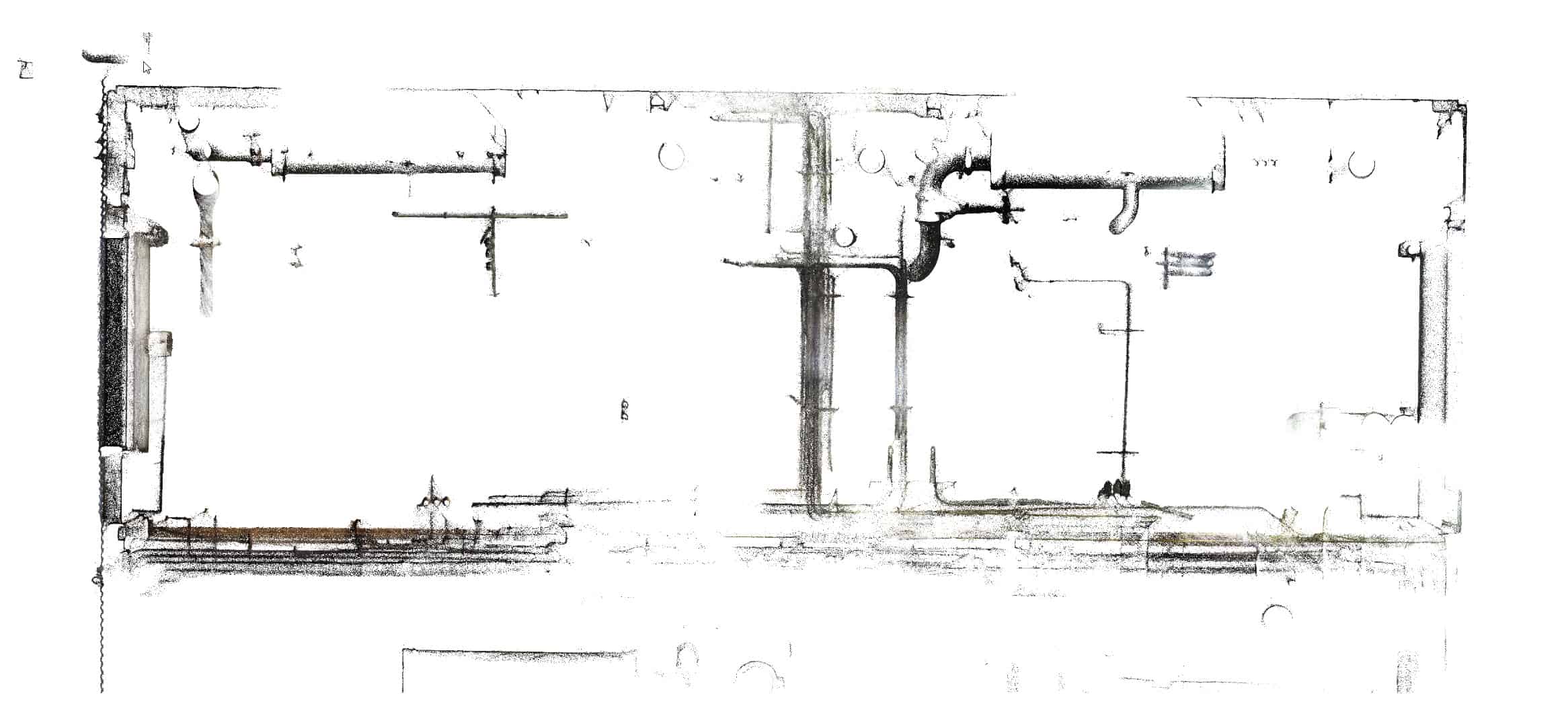
Looks similar to the GeoSLAM equipment. I demo’d a Zeb-REVO a while back. It’s pretty slick for stuff like floor plans and tree surveys. The processing software had a floor plan routine that would translate the scan to a 2D CAD drawing. Processing is pretty fast and hands-off thanks to the SLAM algorithm.
I remember the relative error being about about 3cm. Range is limited compared to most static terrestrial scanners, but these things are usually billed for indoor work.
If we did more condo plats I would kick and scream at management until they got me one. Far faster and easier than a crew spending days taping multiple floors of units, then trying to square everything up and calculate a CAD drawing over the next day. Walk the building with a PX-80 or equivalent in less than half the time, let the workstation crank away on the data, then grab the 2D files and start dimensioning.
“…people will come to love their oppression, to adore the technologies that undo their capacities to think.” -Neil Postman
Similar to Geoslam, but cheaper. I don’t like cables, in my experience the cable has always been broken first. I hate when an expensive tool can’t be used because of the cheapest component to break down. The PX-80 does not use any cables in the field, so I chose this one. I surveyed industrial halls, offices, residential buildings. Great for stockpile surveying too. Just walk and scan. The problem was measuring small rooms, where if I suddenly turned the device over, the scan drifted. The new softver version seems to solve this problem. I also find that the relative error is around 3 cm, but it can be reduced by noise filtering.

What is the price of paracosm system? I was looking to buy a geoslam revo but the bottleneck is the software that is sold separately.
Also after 20-30 minutes of scanning you will receive a big drift of you pointcloud..
About 29500$.
Paracosm say: “Keeping interrior scan under 15 minutes in lenght, exterrior scan under 35 minutes in lenght.”
They also have a measurment method to avoid drafting.

I’ve looked at the dataset from paracosm and when i slice in pointcab for a planview it doesn’t look to bad
When i take a section view, it looks very disturbing. Not very level. I hope they resolved this at the moment.
I recently went to a demo of the blk2go from Leica and was pretty impressed. My findings are on this post on the Laserscanning Forum
https://laserscanningforum.com/forum/viewtopic.php?p=83326#p83326
Slam technology is the future i think but have a long way to go.. Price incuded and software?
Because geoslam including software cost 50.000$ plus vat
I don’t think this is a bug in a PX-80, but it’s easy to fix in Cloudcompare or Pointcab. I’ll look.
It has a small viewer “Retrace” with measurment and a little dxf export, but CloudCompare is free and has a lot to do with it. I’m in Europe, I don’t know your tax rules. You can inquire here: https://paracosm.io/
Sorry! Now 32500$!
The demo’d workflow for interiors had the operator move backward into each room so as to keep common features in “sight”. Helped the SLAM routine place the new room in relation to the adjacent room.
“…people will come to love their oppression, to adore the technologies that undo their capacities to think.” -Neil Postman
Hello, do you think this is a Survey quality system that would be effective for urban environments and/or topos in the woods? Please speak to the workflow getting data into cad and accuracy with noise filtering. Thanks!

Hello,
I was planning to apply SLAM over a MMS-point cloud but I realised that there is no overlap between consecutive scans (from consecutive poses of the sensor).
This is due to the fact that the LiDAR sensor used rotates around a horizontal axis, resulting in vertical scans (vertical lines parallel to each other) without overlap between them. However, the distance between the lines can be very short, e.g. around 1 cm when the MMS moves slowly.
In addition to this, every survey consist of 4 runs which are processed together and averaged. So, every area is revisited 3 times. In this sense, there is certainly overlap, but not among consecutive scans.
I was wondering if it could still be a way to perform SLAM in this situation.
Regards,
Pablo
Hello,
I think my english is too weak to this. The MMS uses 3 items when scanning: IMU, GPS & Scanner. The SLAM just 2: IMU & Scanner. I think MMS is better but much more expensive. I do not know the internal operation and processing of the scanner. I just a user.

Hi,
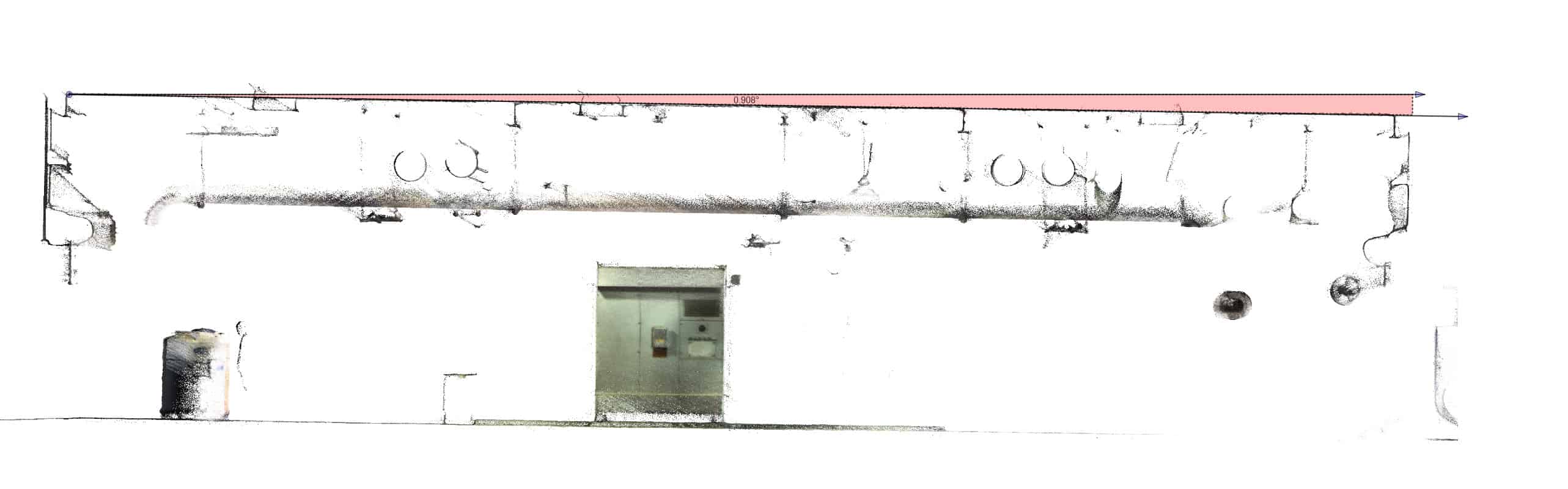
We have been using PX-80 for months. We used it in different projects including street scans, stock-piles, industrial and forestry; the backpack gear is perfect for outdoors. We also have a battery kit which gives us 5+ hours in the field. I definitely suggest for folks who need a quick solution with good accuracy. We get 2-3 cm accuracy and less noise than Geo-Slam for sure. This is a data snapshot from scan in NJ:
Hi,
I’m so glad I’m not alone. Let’s keep in touch! I have a question right away. Have you ever measured an overpass over an electrified railroad? Does high voltage affect the IMU? I tried four times, all bad!
Hi,
I haven’t tried the PX-80 near high voltage zones, but I think it’s normal get bad results with the IMU because of the magnetic field. I know that consumer drones loose control in close proximity of power lines. For such works I use terrestrial scanner, didn’t have problem with that.

Hey,
Does px-80 worth it ? In the process to buy a used one at a good price but wondering if it worth is money . We mostly want to use px-80 to survey old buildings interior and exterior and prepare 2d plans , horizontal and vertical sections , facades etc


Log in to reply.