
Activity Feed › Discussion Forums › GNSS & Geodesy › Datums
Datums
Posted by MightyMoe on January 16, 2019 at 10:01 pmUsing Trimble software I set up a job in WY East Central Zone.
I put in a point at an even latitude longitude location as NAD83, the entry type selection is Gobal.
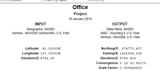
Then to check that the calculation in TBC is correct I check it in Corpscon NAD83 geographic to WYEC XY:
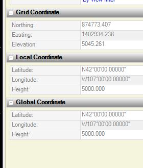
I export the file to my data collector and review the point, I don’t have a screen shot of that but the review options are: grid, local, WGS84
the grid is identical to TBC and Corpscon, the local (NAD83) lat, long is also identical to the screen shots and the WGS84 is N42d00’00.00000″,
W107d00’00.00000″.
Of course NAD83 and WGS84 are not identical, but this is how the program displays them, I believe this has caused much confusion from end users. It is my understanding, although I’m not an expert, that WSG84 corrections are not available to the public. I could be wrong about that, unlike the reports sent by OPUS and RTX that send out NAD83, ITRF and IGS coordinates.
Here in the states I seed my coordinates with NAD83, other parts of the world have different datums to use, but I don’t think anywhere the basis for an XY grid is WGS84 geographic.
thebionicman replied 5 years, 3 months ago 4 Members · 10 Replies- 10 Replies


I used WGS84 in Kuwait last year for data collection. They have a variety of suspect and bizarre local networks that have evolved over the past 70 years. There is no other option there.
I used TBC to process the data and when they were available, I just applied the IGS final orbits to complete my data packages.
Worked like a charm.
 Posted by: Jitterboogie
I used WGS84 in Kuwait last year for data collection. They have a variety of suspect and bizarre local networks that have evolved over the past 70 years. There is no other option there.
I used TBC to process the data and when they were available, I just applied the IGS final orbits to complete my data packages.
Worked like a charm.
You had a service that sent corrections in WGS84?
I’m only curious, I’ve never worked in it, but it’s always displayed in my Trimble jobs using the identical # as the NAD83 value. Was this military?
I only collected in WGS84, raw data.
No, not Military, but subbed out From the Kuwait Oil Company(KOC), and saw weird GPS results too. From the In Theatre jamming that the US Armed Forces applied at random intervals during their flight ops and training with the Kuwait Air Force etc..
Good Fun.
And was even coerced to attempt running level loops from the beach to the accepted benchmarks to set control. I roundly disapproved and shut that insanity down immediately.

If I were paying a subscription or buying equipment from Trimble, I would be loudly complaining about their confusion.
Your datum is set by whatever datum your corrections come from. That should be known or made known to the software. If you know what that is and want to transform to another datum, the software should know how to do a realistic conversion. NGS does it, and proprietary products should be able to do it too.
It’s my understanding that WGS84(week#) is IGS at that epoch. Since continents move, the epoch is important metadata.
The WGS84=NAD83 heresy comes from the days when it wasn’t possible to measure that difference accurately.
.When a file is set-up in the software, it will expect you to provide coordinates that are relevant to that projection. The above example is a CONUS state plane file so it expects the geographic coordinates to be NAD83. If you provide ITRF or IGS #’s for the Global Lat, Longs, your state plane numbers will be off by that shift. My point is to be sure what your software is doing.
For me, when I started, I thought I was working in WGS84 because the software displayed the underlying coordinates as WGS84. I was wrong of course, but I learned quickly and understood that NAD83 was what I always worked in and there was a slight difference between them. That is getting on to 24 years ago now, it is a legacy holdover and to be fair I’m not using the latest and greatest version on my DC.
But, I think there is much confusion still about the datums. It was my understanding that WGS84 is proprietary to the DOD and we slubs were not allowed access to precise corrections in that datum. Maybe that was years ago and it’s all changed now, heck I was out there when it was dithered.
I did read that WGS84 and ITRF are identical within 1 meter.
I long ago quit thinking about it, but it seems to come up a lot lately, we will soon be moving away from NAD83 with the new 2022 systems, but they still will not be WGS84 based as I understand it, but based on ITRF.
From the NGS website; “WGS 84 is not defined by NGS”, but they will work with the NGA to provide transformations, for whatever that is worth.
In case you don’t know what the NGA stands for, it’s the National Geospatial-Intelligence Agency.

In TBC and Access, there is an option to ‘use global as local’. This sets a null transformation so you can bypass the base assumption that WGS84 (the datum, not the ellipsoid) is the basis of everything (which it isn’t).
Once upon a time you could learn geodesy running skipro or trimnet. Now everyone has goofy proprietary crap instead of reasonably accurate terminology. The better you get running the software the less you actually know…
An interesting chart:
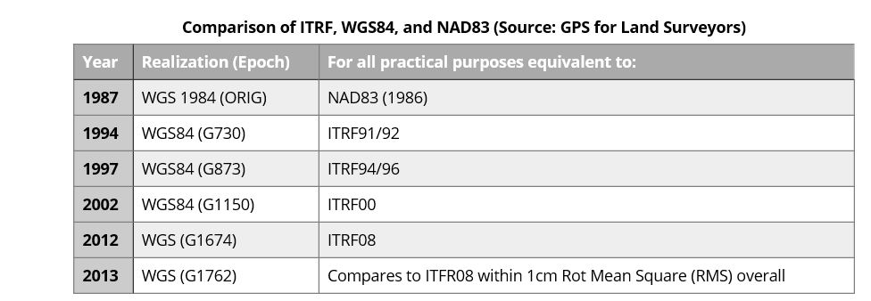
In this chart the acronym WGS84 has been updated by the latest version WGS G1762) which is within cms of ITRF08, as we know ITRF08 is available along with IGS08. The most proper way to obtain NAD83 is to apply the NGS program called Horizontal Time Dependent Positioning (HTDP) to transform ITRF.
As John Hamilton discussed in another thread, do static surveying and adjustments in ITRF then transform the coordinates to NAD83 for use in state plane, ect.
In the beginning of GPS WGS84 and NAD83 (86) were equivalent, it was the 93 adjustment for NAD83 that pulled them apart, of course they would be drifting along no matter what as long as NAD83 stayed local.
I would say you cannot define the ‘most proper’ method without knowing the specifics of what is being ‘matched’.
In a scientific endeavor, most of the methods surveyors use are woefully inadequate. In a surveying scenario, perfect geodetic techniques will put you in precisely the wrong place.
Most of us are attempting to integrate our information into a larger record related to a specific datum and epoch. The best way to do that is by using or validating against local and proven control. Obtaining perfect relation to another datum may enable other uses of the data, but is not superior (and is arguably inferior) in that type of work.
- Posted by: thebionicman
I would say you cannot define the ‘most proper’ method without knowing the specifics of what is being ‘matched’.
In a scientific endeavor, most of the methods surveyors use are woefully inadequate. In a surveying scenario, perfect geodetic techniques will put you in precisely the wrong place.
Most of us are attempting to integrate our information into a larger record related to a specific datum and epoch. The best way to do that is by using or validating against local and proven control. Obtaining perfect relation to another datum may enable other uses of the data, but is not superior (and is arguably inferior) in that type of work.
I agree, most of my work is using legacy control, from DOT to FEMA, it’s important to mesh into what is already established.
And I will not go through the process John does for a pad site on a remote location.
It will be interesting to see what happens when the ITRF takes over and grid coordinates slide fairly quickly.
I’m looking at 3 T2s and a cubitape this weekend. Should give me a few options…????

Log in to reply.