
Activity Feed › Discussion Forums › GNSS & Geodesy › Coordinate Transformation
Coordinate Transformation
Posted by nezuko216 on March 23, 2020 at 6:53 pmHow do I convert the original realization of WGS84(1987) coordinates to ITRF14 @ epoch.yyyy, say epoch 2017.75? Is there some tools I could use?
geeoddmike replied 4 years, 1 month ago 6 Members · 16 Replies- 16 Replies

Try this on for size: https://www.ngs.noaa.gov/TOOLS/Htdp/Htdp.shtml

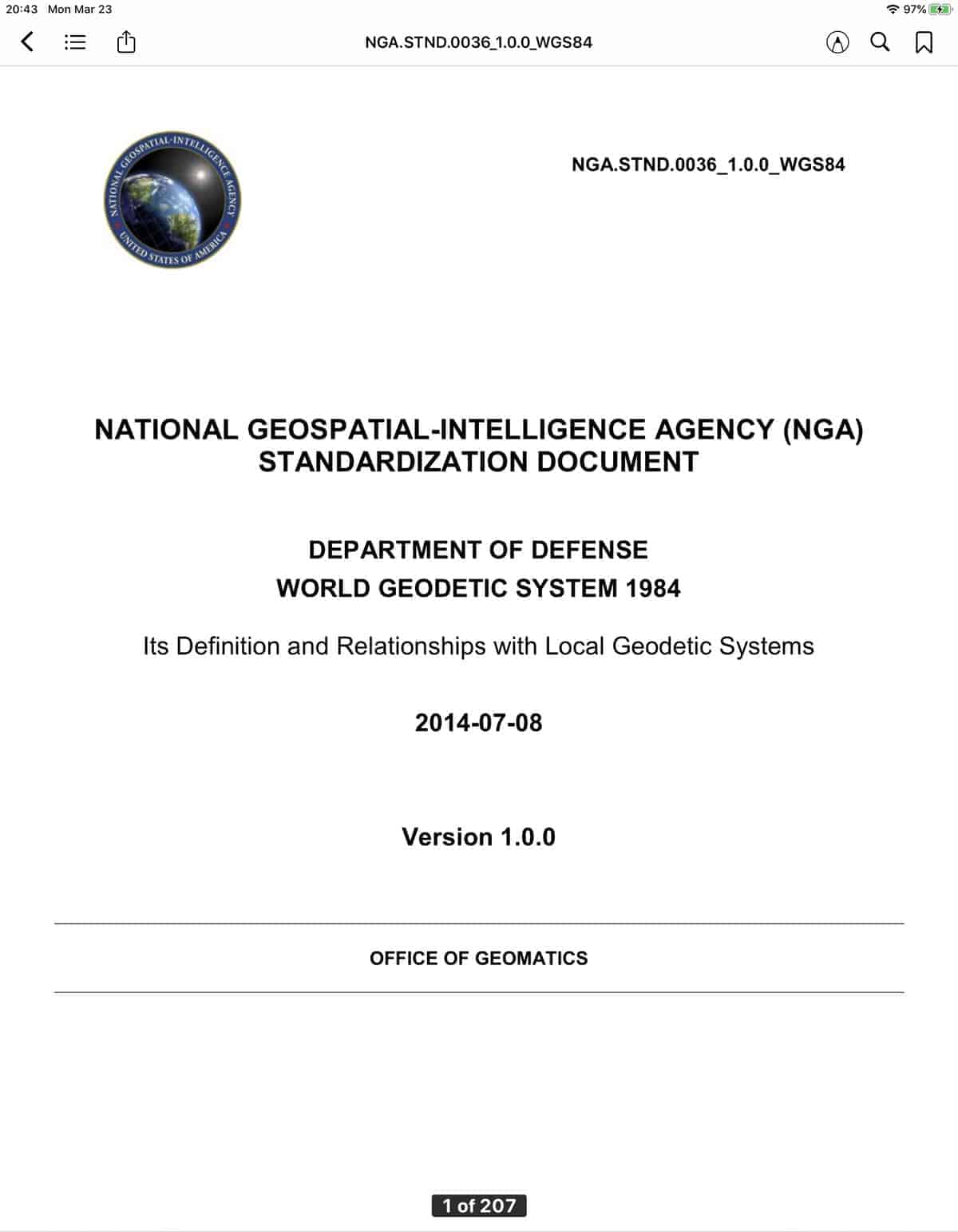
I agree that HTDP is the best tool. I also recommend reading the documentation. For more detailed info on the relationship of WGS and other datums see:

@steinhoff Sadly, it won’t work for the area I’m working in (ASIA), it gave me an error of ‘outside of the modeled area’ when trying it. Seem to work only to US.
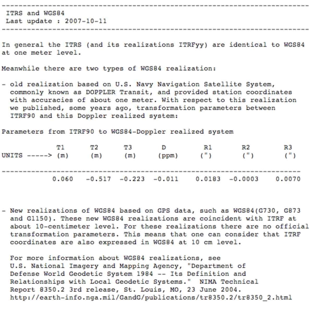
I note that you refer to the ??original version of WGS 84 with the date 1987. While the original version of NAD 83 is labeled in NGS records as NAD83 (1987), I am not aware that that is the designation used by DMA and later NIMA then NGA.
I am curious about the origin of your original version WGS 84 coordinates. As the document above and the message below indicate the original WGS 84 was of meter-level accuracy. My experience has been that many records of GPS surveys into the 1990s labeled their data as WGS84 even though the surveys used NAD 83(1987) or later versions as their fixed control.
The original version of WGS 84 was DOPPLER Transit based (as was NAD83 (1987)). FWIW, I provide the following:
This information was from NIMA TR 8350.2 that was superceded by the NGA document linked in my prior message.
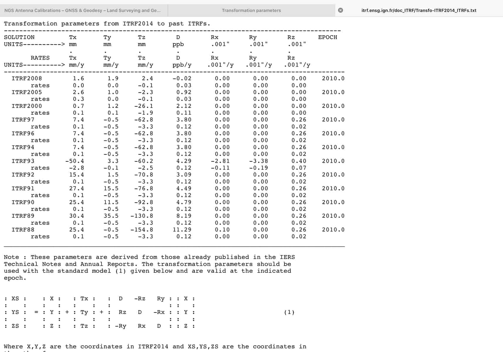
Here is a tabulation of transformation parameters from ITRF 2014 to all previous versions.

There is always the possibility that at that time the creator of those coordinates may not have had the ability of today’s surveyor. I would only use those coordinates. transformed or not, to search for unfound corners from found and occupiable corners. or to reset same using vector data from at least 3 other points.
Paul in PA

I think it’s important to note that the DoD (DMA,NIMA,NGA) has never provided any high accuracy terrestrial realization of WGS 84 (passive or active control stations) to the civilian community. Anyone who thinks they have high accuracy (better than about 2 m) WGS 84 positions in any of it’s six iterations better check the corresponding references to their origin of the data. If you tied to an ITRF referenced station such as NGS CORS and then called the data WGS 84 (G-whichever) that would be legitimate but should be noted in corresponding metadata. The original realization of WGS 84 is now often referenced as WGS 84 (Transit) since it was determined by Transit Doppler observations as previously noted by GeeOddMike.
Unfortunately in the vast majority of occasions when someone has approached me with some situation dealing with WGS 84 coordinates and I inquired as to the origin of those values it was typically a deer-in-the-headlights moment. “It’s what came from my computer” was pretty typical. Further investigation often found they had typically tied into a published NAD 83 station and didn’t really understand the difference in datums.
I should also note a minor correction to his reference to the original NAD 83 as 1987. It was originally published by the National Geodetic Survey in the summer of 1986 without the date as part of the datum designation. With the subsequent developments of the state-by-state High Accuracy Reference Networks and regional readjustments of NAD 83 beginning in 1988-89 the designation was changed to NAD 83 (1986).
@geeoddmike the way I understand it, these transformation parameters from ITRF 2014 to all previous versions you attached are on base epoch 2010.0. Do I need to transform coordinates from ITRF14 @ epoch 2017.75 to ITRF14 @ epoch 2010.0 in order to use these parameters or I’ll just simply replace ‘2010.0’ with 2017.75? Regarding the first question how does one convert say, ITRF14 2017.75 to ITRF14 2010.0? I’m very sorry for these questions I’m a newbie in surveying. Actually did some readings, http://itrf.ensg.ign.fr/, https://confluence.qps.nl/qinsy/latest/en/international-terrestrial-reference-frame-2014-itrf2014-182618383.html but didn’t find the answers I was looking for or so I thought.
 Posted by: @nezuko216
Use HTDP linked above, which will let you specify the epoch, to do the best job possible, and heed Paul’s warning below about relying on the result.
.HTDP works anywhere in the world. You need to provide velocities from CORS in your area of interest – select “Specify the velocity in terms of north-east-up components (use the input boxes below)”. Only velocities for US CORS are built into the model. I just ran a test with made up velocities in the area of Phnom Pen and the program worked just fine. You might be able to find these data for CORS in your general area from the IGS — http://www.igs.org/
Thank you @base9geodesy I really appreciate these helpful comments. The problem is I don’t really know what these ‘velocities’ are and what to look at IGS you link above. I did some google and I hope you don’t mind my asking does this tool https://www.unavco.org/software/geodetic-utilities/plate-motion-calculator/plate-motion-calculator.html help get those velocities for my point?
Thank you for valuable comments. Such a friendly community with great experts. I think I found a solution. Cheers.
Looking at the following IERS page:
https://www.iers.org/IERS/EN/DataProducts/ITRF/map/itrfmap.html
We see the paucity of stations in Southeast Asia.
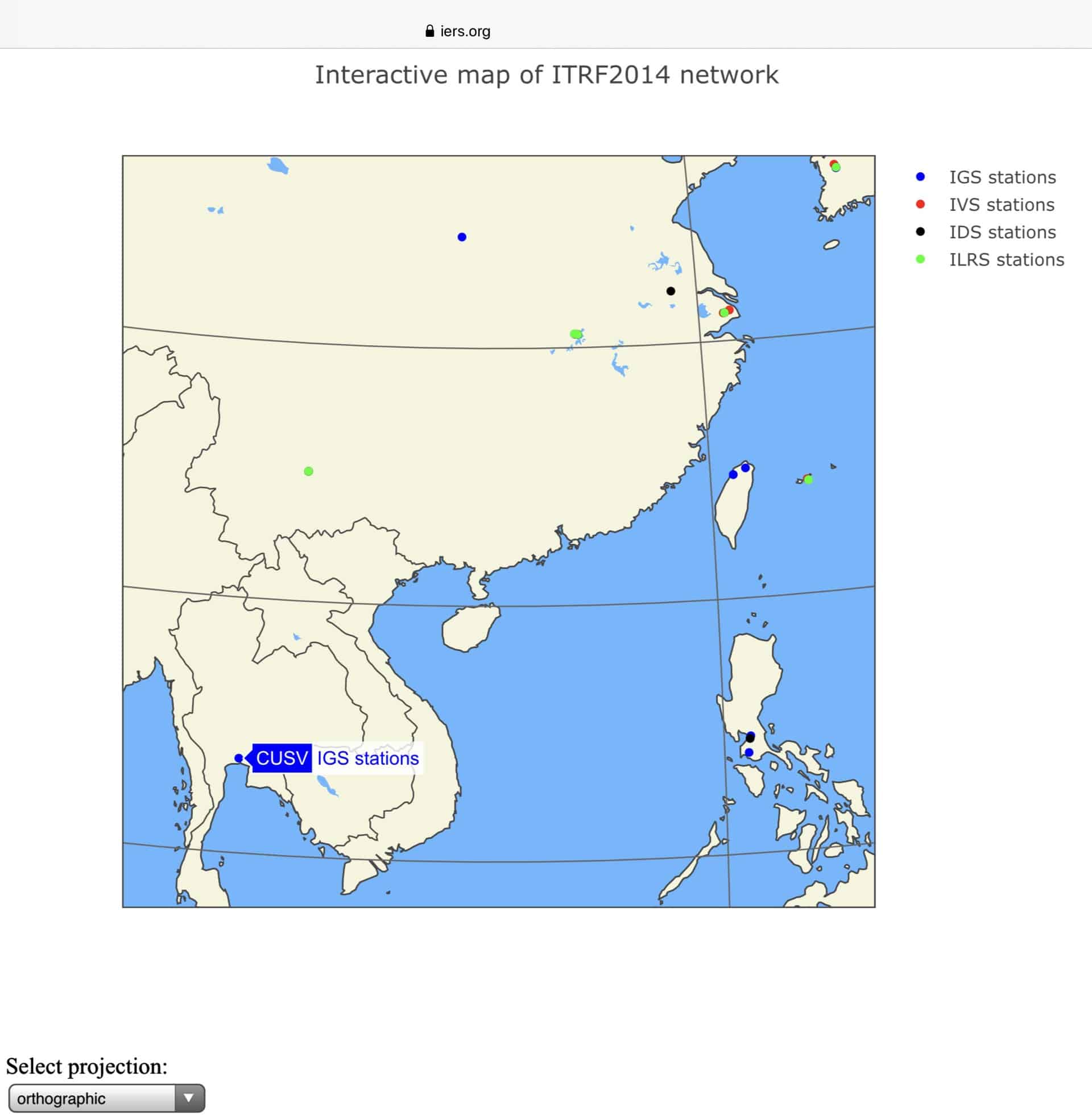
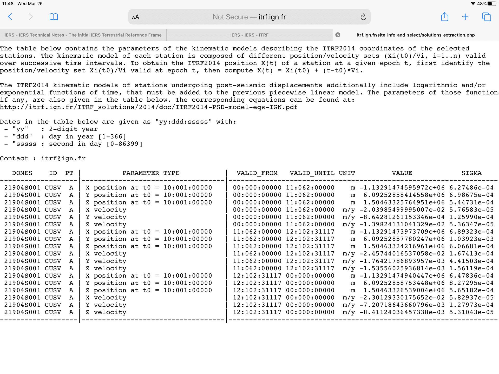
There is a relatively recent site at Chulalongkorn University in Bangkok, Thailand. Its DOMES is: 21904S001. It was not included in versions of ITRF prior to the current ITRF2014. Station positions and velocities are shown below:
As for transformation between frames and times see:
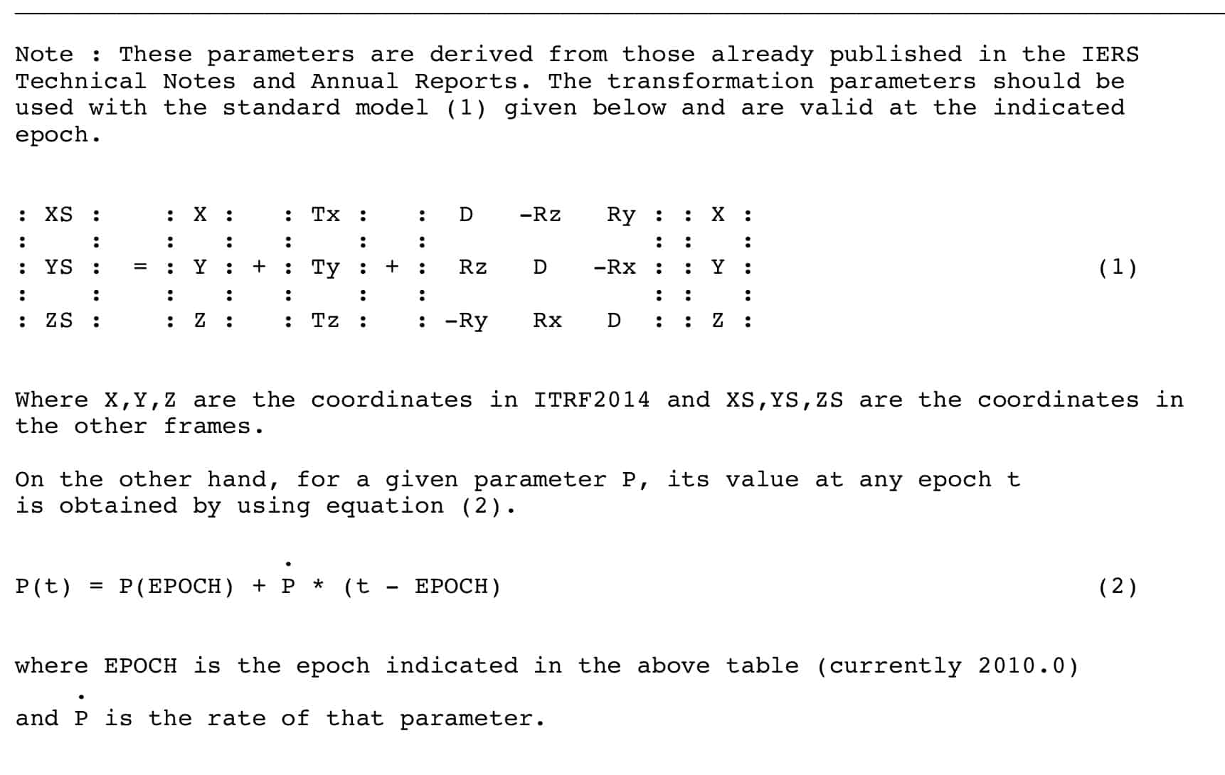
Be sure to use the correct units: Translations are in mm, Scale (D) in parts per billion (ppb) and rotations in milli-arcseconds (0.001 seconds). Like most geodetic computations they should be done with attention to significant figures.
Reading later in this thread I see you have solved your problem. Good. I also note that my error when referring to the original NGS version of NAD 83 was identified. Thanks base9geodesy. Hard to recognize that 1986 was so long ago, as was my retirement…
Yes Nezuko216 the UNAVCO estimates should probably give you what you need. I should have thought of that – I claim a senior moment. Good luck. Remember that it’s highly very that the resulting transformed values could easily have an uncertainty of +/- 1-2 m.
I prefer to the IERS technical notes available here: https://www.iers.org/IERS/EN/Publications/TechnicalNotes/TechnicalNotes.html
Number 38 is for ITRF2014.
As for applying differences in time to your computations, I understood from your original post that you had WGS coordinates only. Without knowledge of the date of the coordinates you risk applying decades of velocities erroneously.
If you read the NGA reference in my first reply you will have noted that WGS 84 does NOT include a provision for velocities. The NGA policy as I recollect is to monitor the relationship between WGS 84 and the the current ITRF. When it exceeds their threshold (5cm?) they recompute their monitoring sites using IGS precise orbit products as described in the referenced document.
BTW you might also add FIG to your reading list. They had their 2019 meeting in Hanoi with presentations relevant to your region. See: https://www.fig.net/
Good luck,
DMM
Yeah, it just doesn’t seem like it’s been that long. As is so often said – seems like only yesterday – Renee sends you her regards.
Tell Renee Maybe I’ll see her the next time we’re both in Dublin. I’m overdue for another visit.
Hope you and yours are healthy and happy. Who needs anything more?


Log in to reply.