
Activity Feed › Discussion Forums › Education & Training › PLSO 2018
PLSO 2018
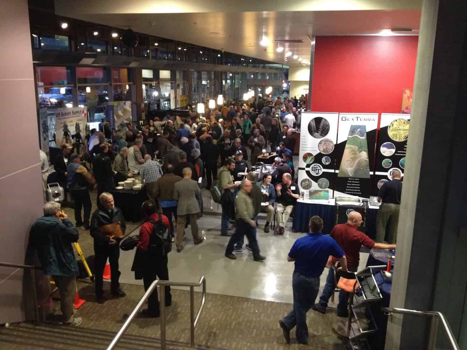
Posted by shelby-h-griggs-pls on January 17, 2018 at 4:43 amAttending the PLSO conference in Salem, Oregon next three days, hope to see old friends here and make new friends. I will be in the geoTerra booth at least some of the time.
SHG
richard-imrie replied 6 years, 2 months ago 11 Members · 17 Replies- 17 Replies

See you there!
Shelby is shown here seated next to his GeoTerra display in tan pants and dark shirt, looking towards John Putnam, who stands in green shirt with backpack.
Mike Berry gave a very excellent presentation on Oregon Right of Way law this morning and is set to repeat it tomorrow. No doubt he will be asked to do it again in the future as well.
Another presenter made the case that one could purchase a suitable drone, get the appropriate FAA license and insurance coverage, necessary software and training, and be mapping from drone photography for an outlay of under $10k. As a matter of fact the numbers he had seemed to suggest it could easily be well under that.

We have 4 pilots, one drone and a processing subscription for portions of the work. Total outlay around 10k. We could have done it cheaper but productivity is immediate…

Pretty disappointed I can’t make it this year.

I’m finishing up this afternoon attending the GNSS user group meeting. Great conference!

And it is in the books, didn’t attend all sessions, having a booth and all, but I figure I got about 11 hours of seat time in actual classes. Good seeing a bunch of folks there!
SHG
 Posted by: Mark Mayer
…Another presenter made the case that one could purchase a suitable drone, get the appropriate FAA license and insurance coverage, necessary software and training, and be mapping from drone photography for an outlay of under $10k. As a matter of fact the numbers he had seemed to suggest it could easily be well under that.
Under $10k, AND a trip to Salem to visit with OSBEELS for an informal conference about practicing photogrammetry without a license… cool technology but not worth it to me.
As a side note: I heard at the conference that there are only 48 photogrammetry licenses in the state of Oregon. I think they mentioned that at one of the lunches.

I was talking to friend (PLS) a couple of days ago at the saloon, and he was telling about his new plan to buy a drone & some software, get his FAA license/certification/whatever, and start making big bucks doing his own photogrammetry.
I dunno…sounds like an accident looking for a place to happen. I hope that he does okay, but we’ll see!
I can’t wait to pull the plug into [semi]retirement this fall (50th anniversary of starting surveying), I’m convinced that technology has surpassed the threshold of understanding of far too many [land] surveyors.
Oh yeah…get of my lawn!
Loyal
 Posted by: Loyal
Oh yeah…get of my lawn!
Loyal

As I tell many, when as a full service mapping company we can see the business case for adding a drone, we will, certainly less $$$ than the big stuff we already own, almost pocket change in comparison and we already have pilots and staff for image processing in place, it seems like it would be a no brainer for us and yet we watch from the sidelines, hmm.
I think for small projects of less than 40ac, transmission line inspections, bridge inspections, etc., small open pit mines and stockpiles and other volumetrics they make sense, BUT not necessarily as a service, I think you will see the power companies, mining companies, gravel operators, etc. buy their own drone for internal usage. I believe a lot of ag users already do this. There are of course smaller projects that actual surveyors may be able to map internally without hiring a full service mapping company such as ours, but just because it is the current hot topic and buzz word doesn’t necessarily mean it always is a good business case.
SHG
 Posted by: thebionicman
We have 4 pilots, one drone and a processing subscription for portions of the work. Total outlay around 10k. We could have done it cheaper but productivity is immediate…
If you don’t mind sharing: What hardware/software/training course do you use or recommend?
We aqcuire data with a phantom 4 pro and use aerotas service to stitch photos. They cost less than a Pix 4D license.
I do my surface with Virtual Surveyor. We are still working out bugs in our 2d planimetry extraction so the flow isnt set in stone. Probably going to involve global mapper to make ecw from tiffs (which are WAY too big).
For pilot training I overdid it. I took the FAA intro followed by Remotepilot101, then the Aerotas training. Hands down remotepilot101 is where its at. None of the ‘apps’ show our airspace correctly and they prepare you very well for the test and real world.
- Posted by: thebionicman
We aqcuire data with a phantom 4 pro and use aerotas service to stitch photos. They cost less than a Pix 4D license.
I do my surface with Virtual Surveyor. We are still working out bugs in our 2d planimetry extraction so the flow isnt set in stone. Probably going to involve global mapper to make ecw from tiffs (which are WAY too big).
For pilot training I overdid it. I took the FAA intro followed by Remotepilot101, then the Aerotas training. Hands down remotepilot101 is where its at. None of the ‘apps’ show our airspace correctly and they prepare you very well for the test and real world.
Cool, thanks for sharing. I’ve been demoted to “management” in our shop, so I’m unfortunately a little removed from the hands on. Always like to hear what others are doing. We have a phantom4 and a phantom4 pro. We use Agisoft Photoscan. I think 5 of our guys have gotten their flight certificates. I haven’t heard of the aerotas service, so I’m going to check that out. I’m also really interested in 2D feature extraction–I think that will be the biggest bang for the buck for us by far.
We make mad heavy use of Global Mapper. For coordinate system transformations, point cloud and image handling, turning tiffs into ecws, etc., it’s a lot of tool for the money.
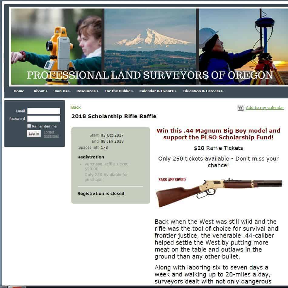
Speaking of the PLSO Conference.. anybody know who won the rifle?

Rod Taylor with US Survey supply. He says it shoots real nice!
Glad to hear it’s being used. I figured it was going in somebodies safe…


Log in to reply.