
John Henry vs. iPhone stockpile measure

A couple weeks ago I saw a demonstration of an iPhone app which measures the quantities of stockpiles.
The company that developed this worked with Kniferiver on a bunch of stockpile sites in the Portland area and throughout the northwest to perfect the program. They say they hit within 1% to 2% of LIDAR measurements.
The tool is an iPhone 5 or 6 app and once the measurement it complete, you up load it to the company’s web site. It is then processed and I believe they say in 18 hours you have your quantities and tonnage (based on the factor you give them). We measured this pile at noon and it was available the next morning. The cost is something like $50 a pile. The app is free, you buy a subscription to have the data processed.
Briefly, two traffic cones are placed 25 feet apart in front of the pile. You start filming with the iPhone in video mode at the right-hand cone (#1), walk clockwise past the left hand cone (#2), and continue around the pile. You finish by overlapping your filming past cone #1 and end at #2. The phone has to have GPS activated. When you start walking the pile the program methodically beeps, letting you know that you are doing OK. If you turn the camera away from the pile, are too shaky or in some other way do something the phone thinks is weird, it buzzes and beeps and farts out warnings. Once the measurement is complete it will identify sketchy areas and let you review the short video clip of these areas
Cones. The distance from the cones to the pile does not matter. You just have to be sure the cones are 25 feet apart:

Videoing a pile (different pile from the one shown below):

Your distance from the pile can vary along your circumnavigation, just as long as you have the bottom and top of the pile in the screen. The video is shot in portrait format:

Another nearby pile necessitated scooting in closer to the measurement pile which meant top and bottom could not be filmed. They said to keep the top in view. Once the constriction ends you drift away to get the top/bottom view again. I believe it then interpolates the missing segment along the toe of the pile. This happened for about 50 to 80 feet on the pile we measured:

You do not film the top of the pile. They said they offer other methods of measurement for piles that are dished in or have significant volume heaped up beyond the “false summit” you view from the ground.
Here is a clip of the report from the test stock pile (13,550 cu. yd.):

The next day we measured the pile. Over 500 shots. Here’s our measurement (13,148 cu. yd.)

I made a volume DTM from our work and contoured it to get “fill contours” (rather than elevation contours)and then roughly scaled/rotated an image clipped from the iPhone contour pdf into the Acad drawing to compare (note that after we measured the pile the contractor began hauling loads out of it. You can see the difference in the “face” of the pile as noted below. The decreased yardage was nominal.) The black 1 foot contours are the iPhone contours and the blue are the survey measure 5’ index contours:

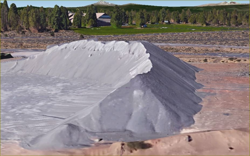
Here is a rough oblique view rendering of the pile from the SW, the “face” is on the left. The top had a bunch of 1 to 3 foot hummocks:

Log in to reply.