
Activity Feed › Discussion Forums › Strictly Surveying › Jobsite benchmark
Jobsite benchmark
Posted by chrish on February 15, 2018 at 8:28 pmNow if only if all my construction plans had this included… Is it normal in construcrion plans to leave this out? This is the first one ive seen in the 2 months I started, that ive seen it included.
 MightyMoe replied 6 years, 2 months ago 7 Members · 14 Replies
- 14 Replies


Definitely good info to have.
If I did the conversion correctly, its location appears in google earth to be a bit vulnerable to someone deciding to take a big machine across the alley and park it with a wheel on top of the bm. Maybe GE is off a bit and it is really closer to the fence than it looks.
.
I havent looked up what it shows in google earth but it is about 10?? from the fence id say.
And you are correct, this thing has been driven over a thousand times already. It appears to be just a piece of rebar pounded into the ground to slightly below the surface.
This job is nearing the finish line anyway.
The guy before me started this job, this was just the first time I came across a job with a BM listed.
I found out that my rover was showing elevation .5?? higher than what it was supposed to. Looked to me like the calibration was messed up. But floor elevation was right where it needed to be when we measured from the top of some existing curb to the new finished floor.
This job has definitely come with a lot of headaches…

I would expect to see more than one control point on a site.
3 should be a minimum.
I would suggest going forward when you do a site survey for design to leave at least 3 inter-visible points for the next phase.

Having a statement about an elevation benchmark is common. Having horizontal coordinates – not so much. In fact I can’t recall ever seeing it.

I would believe it is very common with a benchmark established by GPS, so that you can confirm it or prove otherwise.
Your rover being 0.5′ off might say something about your rover.
Typically my note would include “Per OPUS Observation” so one would know it was static and of some duration. Were SPC a required contractual agreement, I would include the names of the CORS. Had I also occupied an NGS benchmark, I would include the referenced station and elevation and my observed elevation.
Paul in PA
I was at our equipment dealer(Sitech) today and got some good advice from the guys there and they also seemed to be more than willing to help.
The machine on site also showed .5?? too high so unless all our equipment is malfunctioning in the exact same way… its probably a calibration issue. And since this job is nearing completion, im not gonna worry about it too much… just concentrate more on setting up our new jobs the right way from the start, with good control points and machines that have their antenna heights with correct measurements and not cutting 3? too low everywhere… ?
0.5′ is roughly the difference between ’29 and ’88 in that part of the world. Just sayin’
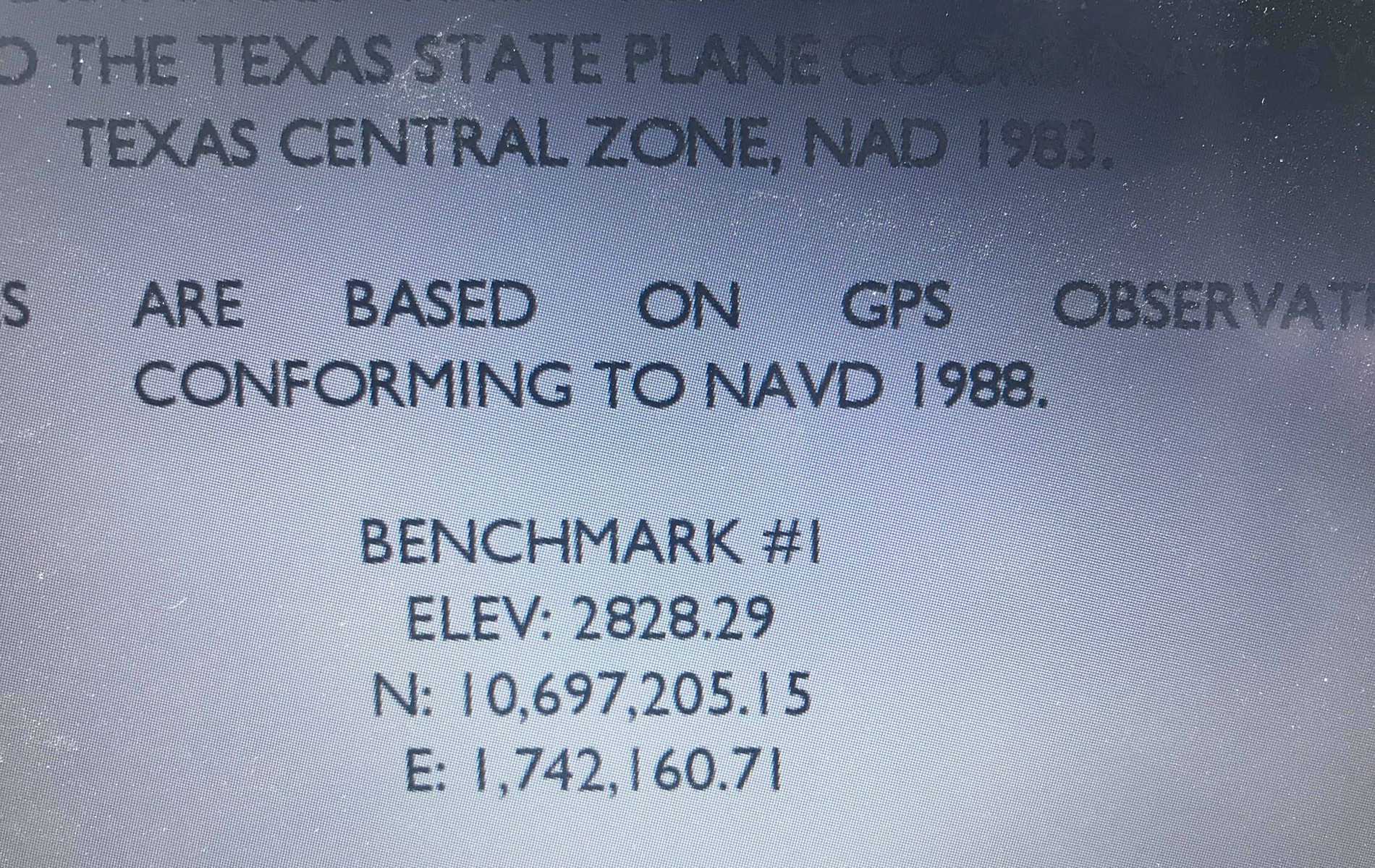
I doubt its a difference in datum issue. I looked at the data collector and saw the control point elevation set for the BM was 2828.79. maybe it was a typo from the previous guy in my position? Or maybe he calibrated to a different point or set of points and the BM was established after the job was started? Who knows… I hate picking up where other people left off…
The piece of data I don’t see is does the Bench Mark conform to NAVD88 as stated. To figure that tying to local bench marks would be the best way to find out, when I did a quick data search there are lots of them near, the first few I looked at were first order bench marks.
In a community of that size elevation control is usually preserved over time even if the bench marks disappear. Often the city engineering department will have records.
In my picture it says it conforms to navd88.
I have not checked against any NGS benchmarks im kind of starting to just forget about them the website lists a bunch of them but more than half the time I cant find them or they look like theyve been disturbed or they are just so old that i dont trust it. Unless there is something im missing?
- Posted by: ChrisH
In my picture it says it conforms to navd88.
I have not checked against any NGS benchmarks im kind of starting to just forget about them the website lists a bunch of them but more than half the time I cant find them or they look like theyve been disturbed or they are just so old that i dont trust it. Unless there is something im missing?
That’s always the issue with bench marks, but I would do my best to figure it out if I worked in an area often.
I would check with the engineers at the city, see if they have preserved the elevations over the years.
Then best way to check if bench marks are disturbed is to check the elevations between them, that’s pretty simple and quick with GPS

 I hope everyone has a great day; I know I will!
Unless you are required to be ‘on NAVD 88′ for whatever work your doing…project control will most likely control your job. What if you go tie into 2 NAVD 88 mons and find the project control to differ by .3′ 1.1’. It’s extremely unlikely they are going to change the plans and existing data. At some point in time project control is project control regardless of what datum it is reported to be on.
I have to agree, project control supersedes.
It appears that the OP handled all that very well, checking the finished floor, curbs. There are usually some important key points that need to be verified with any construction project. Curb tie-ins, drainage structures, finish floors. Like an engineering colleague once told me; the #1 thing in engineering design is drainage, the #2 thing is drainage, the #3 thing is drainage, ect……
The importance of NAVD 88 for most applications is that it can be a data base that hooks into other data, this board discusses FEMA often and I would bet it’s the data for that city, probably for the city sewer system, highway projects, might as well get on it.
What the black box is telling him I can’t say, I don’t have any reference to comment beyond saying CORS/OPUS can be off .5′ from NAVD88 and it wouldn’t be surprising. Mismatching Geoid models with ellipsoid heights can cause that also.
This is an example why only one site bench mark is not a good idea, two are a bare minimum IMO.
Log in to reply.